• Blog
  • Events
  • Network
  • Landslides triggered by multiple earthquakes – a Matlab code

    2019-09-25 | Francesca Ferrario in Software and Applications, Uncategorized | one response

    Moderate to strong earthquakes commonly produce secondary effects (landslides, liquefaction, tsunamis), which worsen the impact of the seismic event, both during the emergency and recovery phases.

    Landslides can be triggered by events of M above 5 or so, and stronger events can produce thousands of landslides. Landslide inventories were compiled for dozens of events and the relations between Mw and maximum distance or area affected by landslides have been analyzed (e.g., Keefer, 1984; Rodriguez et al., 1999). On the other hand, the total area affected by landslides is one of the metrics used to assign the ESI intensity (Environmental Seismic Intensity; Michetti et al., 2007).

    more
  • Masahiko OHKUBOCC BY 2.0

    Hokudan 2020 International Symposium on Active Faulting, 13-17 January, Awaji, Japan

    2019-09-16 | Christoph Grützner in Uncategorized

    The Hokudan 2020 International Symposium on Active Faulting will take place from 13-17 January in Awaji City, Awaji Island, Japan. The symposium is held every five years. The 2020 event commemorates the 25th anniversary of the 1995 Kobe earthquake. All important information on this meeting is available here: https://home.hiroshima-u.ac.jp/kojiok/hokudan2020.html

    This event is supported by INQUA – the International Union for Quaternary Research and its TERPRO commission. For more information, please contact Koji Okumura (kojiok@hiroshima-u.ac.jp) or Shinji Toda (toda@irides.tohoku.ac.jp).

    Deadline for abstract submission is 1 December, 2019.

  • Paleoseismology field trip and theme session at the 36th International Geological Congress – IGC, Delhi

    2019-09-06 | Christoph Grützner in Uncategorized

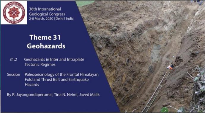
    During the 36th IGC in Delhi there will be a symposium on “31.2 Paleoseismology of the Frontal Himalayan Fold and Thrust Belt and Earthquake Hazards” in the Geohazards Theme 31. Abstract submission is free until 15th Sept. 2019 and open until 15th Oct. 2019.

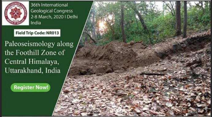
    There will also be a field trip “Paleoseismology along the Foothill Zone of Central Himalaya, Uttarakhand, India” from 25-29 Feb. 2020, Field Trip Code NR013.

  • aZora Films

    Seismic crisis reveals the growth of a young fault system in the Alboran Sea

    2019-09-05 | Various Authors in Paper | 2 responses

    Press note related to the publication of the manuscript “Earthquake crisis unveils the growth of an incipient continental fault system” in Nature Communications (DOI: 10.1038/s41467-019-11064-5).

    An international team led by the Institut de Ciències del Mar (ICM-CSIC, Barcelona) demonstrate the growth of a young fault in the Alboran Sea, called the Al-Idrissi Fault System, source of the magnitude (Mw) 6.4 earthquake, which affected Al-Hoceima, Melilla and the south of the Iberian Peninsula in January 2016.

    more
  • Christoph GrütznerCC BY-SA 3.0

    New papers on paleoseismology, earthquakes, and active tectonics (Sep 2019)

    2019-09-03 | Christoph Grützner in Paper

    The mega-hot summer seems to be finally over (at least in Germany), and most of this season’s field work is probably done. So why not catch up with the latest papers on paleoseismology and related subjects? These are the latest papers:

    more
  • Christoph Grützner

    SSA call for papers on Ridgecrest Earthquakes and historical seismograms

    2019-08-14 | Christoph Grützner in Paper

    The Seismological Society of America has currently three interesting calls for papers.

    • BSSA Call for Papers: Special Issue on the 2019 Ridgecrest, California, Earthquake Sequence: https://www.seismosoc.org/bssa-call-for-papers/
    • SRL Data Mine Focus Section: 2019 Ridgecrest earthquake sequence: https://www.seismosoc.org/publications/calls-papers/srl-call-for-papers/
    • SRL Call for Papers: Historical Seismograms: Challenges and Successes in Preservation, Digitization, and (Re)Analysis: https://www.seismosoc.org/publications/srl/call-for-papers-historical-seismograms-challenges-and-successes-in-preservation-digitization-and-reanalysis/
  • Christoph GrütznerCC BY-SA 3.0

    Postdoctoral Research Assistant in Active Tectonics, Uni Oxford

    2019-08-12 | Christoph Grützner in Jobs

    The Department of Earth Sciences at the University of Oxford is currently recruiting a PDRA in Active Tectonics Research:

    We seek to appoint a Postdoctoral Research Assistant to work closely with Professor Richard Walker as part of a broader consortium in the NERC-funded ‘Looking Into the Continents from Space’ project, whose principal aim is to provide insights into earthquake hazard and crustal deformation through the application of a range of remote-sensing, field-based, seismological, and modelling approaches. The post is co-funded by COMET, which is a world-leading centre for understanding tectonic and volcanic processes and hazards (comet.nerc.ac.uk). The PDRA will join a thriving group involved in remote-sensing and field-based research in the study of active faulting and natural hazards.
    The post is based in the Department of Earth Sciences and will be overseen by Richard Walker, Barry Parsons and Philip England. The post will also involve close collaboration with scientists at the other partner institutions involved in COMET and LICS. The successful applicant will be responsible for the mapping and analysis of fault-based geomorphology using high-resolution satellite imagery and digital topography, supplemented with fieldwork in selected regions. The production of high-resolution digital topographic datasets through field-based, aerial, or satellite methods, forms an important component of the duties. They will also be expected to possess or to develop skills in measuring surface displacements through the matching of optical satellite imagery, and to support both tectonic and volcanic applications of high-resolution imagery and elevation data throughout COMET

    Find more information here: https://my.corehr.com/pls/uoxrecruit/erq_jobspec_version_4.display_form?p_company=10&p_internal_external=E&p_display_in_irish=N&p_process_type=&p_applicant_no=&p_form_profile_detail=&p_display_apply_ind=Y&p_refresh_search=Y&p_recruitment_id=142106

    or at the department website: https://www.earth.ox.ac.uk/vacancies/.

    Application deadline is 9 September 2019.

  • Ridgecrest & Searles Valley earthquakes: a fault displacement hazard analysis

    2019-08-09 | Francesca Ferrario in Uncategorized

    On July 4th and 5th, 2019 two earthquakes (Mw 6.4 and Mw 7.1, respectively) occurred in eastern California and produced distinct surface ruptures. Field surveys started immediately after the first event and, less than two weeks later, a provisional map of surface rupture was compiled and made available to everyone (Contributors from USGS, CGS, UNR, USC, CSUF). I downloaded the map and kmz files of the ruptures from the SCEC response site, which contains tons of fruitful information.

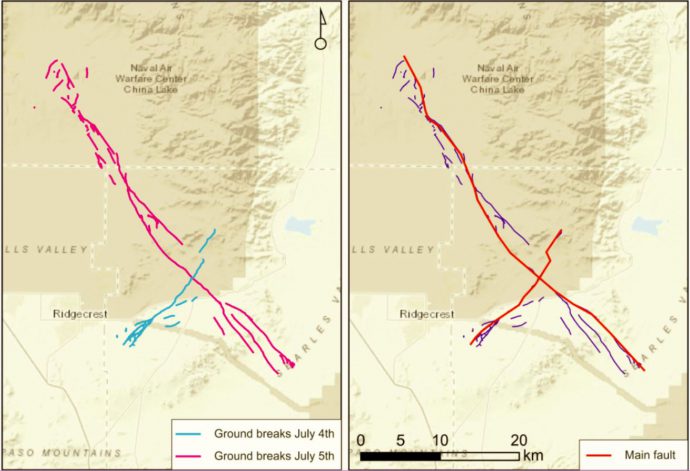
    The two strike-slip earthquakes ruptured two perpendicular faults, the first running NE-SW with left-lateral slip and the second running NW-SE with right-lateral slip (Figure 1). The location of the earthquake falls within the Eastern California shear zone, a region of distributed faulting associated with motion across the Pacific-North America plate boundary, and an area of high seismic hazard.

    Figure 1. Left: ground breaks caused by the 2 earthquakes. Right: simplified trace, used as main fault.

    Ruptures come with a variable degree of complexity: some sectors show a “simple” single strand, others show multiple sub-parallel or diverging splays. Distributed faulting represents displacements occurred off the principal fault and is generally made up by less continuous ruptures, which can be located tens of meters to a few kilometers from the principal fault trace. A method to evaluate the fault displacement hazard has been proposed by Youngs et al. (2003) and later refined by Petersen et al. (2011); the former study analyzed normal faults, while the latter analyzed strike-slip faults.

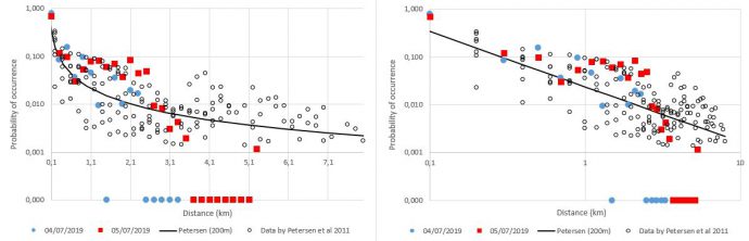
    Basically, the method defines the conditional probability of faulting occurrence as a function of distance from the principal fault and derives scaling relations between rupture probability and distance. I applied the same method on the 2019 sequence and compared the output with the results by Petersen; results are grid-dependent – since available data are still provisional, I used a quite coarse grid size of 200 m, more detailed studies will come.

    Results are in good agreement (Figure 2): the 2019 ruptures show a higher than average rupture probability at 0-2 km from the main fault, but also taper out faster than the previous events.

    Figure 2. Comparison between the 2019 events (blue: July 4th; red: July 5th) and data by Petersen et al. (empty circles). The probability of occurrence of faulting is plotted as a function of distance from the main fault (left: linear horizontal axis; right: logarithmic scale).

    References:

    Petersen, M. D., et al. (2011). Fault displacement hazard for strike-slip faults. BSSA, 101(2), 805-825.

    Youngs, R. R., et al. (2003). A methodology for probabilistic fault displacement hazard analysis (PFDHA). Earthquake Spectra, 19(1), 191-219.

  • Christoph GrütznerCC BY-SA 3.0

    New papers on paleoseismology, earthquakes, and active tectonics (August 2019)

    2019-08-01 | Christoph Grützner in Paper | one response

    This month’s list of papers includes a lot of work on (Central) Asia, New Zealand, and also some nice tsunami stories. Enjoy reading and – as always – please tell us in case we’ve missed something.

    more
  • PATA Days 2020 in Chile, 8-12 November – 1st circular

    2019-07-15 | Christoph Grützner in Uncategorized | 2 responses

    The next INQUA meeting on Paleoseismology, Archaeoseismology, and Active Tectonics (PATA Days) will be held in Hornitos, Chile, from 8-12 November, 2020. Download the 1st circular here (PDF, 400 kb).

    See you all in Chile 2020!

Search

  • Search form
  • Categories
  • Tags
  • Aachen 2013
  • Busan 2014
  • Centerfault
  • Corinth 2011
  • Crestone 2016
  • Earthquake
  • Events
  • Field work
  • Italy 2015
  • Japan Earthquake
  • Jobs
  • Meeting
  • Mexico 2012
  • New Zealand 2017
  • Opinion
  • paleoseismicity.org
  • Paper
  • PATA days
  • Software and Applications
  • Teaching
  • The Friday Links
  • Tsunami
  • Uncategorized
  • Where on Google Earth?
abstract active tectonics archaeoseismology archeoseismology austria Conference deadline earthquake earthquake engineering EEE EGU environmental effects excursion fault field trip field work geology Geology Picture geomorphology germany GPR greece INQUA Italy Japan job jobs landslide lidar links liquefaction meeting mexico New Zealand paleoseismology paper pata days rock fall seismic hazard seismology spain surface rupture tectonics tsunami USA
Page 23 of 92« First‹ Previous192021222324252627Next ›Last »

Pa·le·o·seis·mic·i·ty [ pālē·ə·sīz·mĭs′ĭ·tē ] noun, plural -ties. Ancient earthquake activity.

Paleoseismicity.org is a page dedicated to scientists and everyone else interested in paleoseismology, archeoseismology, neotectonics, earthquake archeology, earthquake engineering and related topics. Different authors irregularly write about recent papers, field work, problems, conferences or just interesting things that they come across. We intend to provide a platform for discussion and scientific exchange. Interested in joining as an author? Please contact us!


paleoseismicity.org is edited by Christoph Grützner and administrated by Martin Schmidt, Koblenz/Germany

© 2008 - 2026 All rights reserved

  • Blog
  • Events
  • Network
  • Newsletter
  • Contact
  • Write for us
  • Impressum und Datenschutz
  • Feed (Atom)
  • Feed (RSS)
  • Feed (RSS2)
  • Facebook
  • Twitter