Press note related to the publication of the manuscript “Earthquake crisis unveils the growth of an incipient continental fault system” in Nature Communications (DOI: 10.1038/s41467-019-11064-5).
An international team led by the Institut de Ciències del Mar (ICM-CSIC, Barcelona) demonstrate the growth of a young fault in the Alboran Sea, called the Al-Idrissi Fault System, source of the magnitude (Mw) 6.4 earthquake, which affected Al-Hoceima, Melilla and the south of the Iberian Peninsula in January 2016.
Geologically, the Alboran Sea is a young basin located between the Eurasia and the African tectonic plates. At the boundary between both plates is located the Al-Idrissi Fault System (AIFS), across the seafloor of the Alboran Sea (Fig. 1). The AIFS is a left-lateral fault system trending NNE-SSW. Despite its subdued topography, it represents the longest active tectonic structure in the region. The fault is about 100 km long and 1 to 4.8 km wide, accommodating a total slip rate of 3.8 mm/yr. The AIFS extends from the Nekor Basin in the Moroccan Margin to the NS Faults in the Almeria Margin. “Our study shows, for the first time, the detailed structure of a fault system on its initial stage.This incipient fault system is a unique opportunity to study the growth and evolution of a young strike-slip fault”, explains the ICM-CSIC researcher Eulàlia Gràcia Mont, leader of this work.
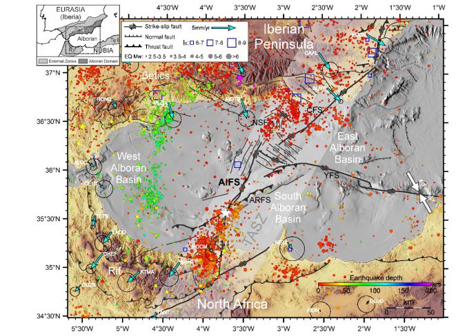
Although this area is characterized by low to moderate seismic activity, large earthquakes occurred in the region, such as the 1804 and 1910 Adra earthquakes, with estimated intensities VIII-X, the 26th May 1994 and 24th February 2004 Al-Hoceima earthquakes, with magnitudes (Mw) 6.0 and 6.3. More recently, during the night of 25th January 2016, a submarine earthquake of magnitude (Mw) 6.4 with an epicenter located in the south Alboran Sea, 42 km from the city of Al-Hoceima, shook the north of the Moroccan coast, seriously affecting the city of Melilla, as well as numerous localities in the south Iberian Peninsula and North Africa. The 2016 event, named as “Al-Idrissi Earthquake”, is the largest quake ever felt in the Alboran Sea since year 1900. The mainshock was preceded on 21st January 2016 by an earthquake of magnitude (Mw) 5.1 in the same epicentral area, and was followed by a series of replicas whose locations migrated southwards and northwards. All these observations as a whole (i.e. foreshock, mainshock and aftershocks) indicate that the earthquake was able to break adjacent faults segments. The occurrence of the Mw 6.4 earthquake supports that the AIFS is currently growing through the propagation and linkage of their fault segments.
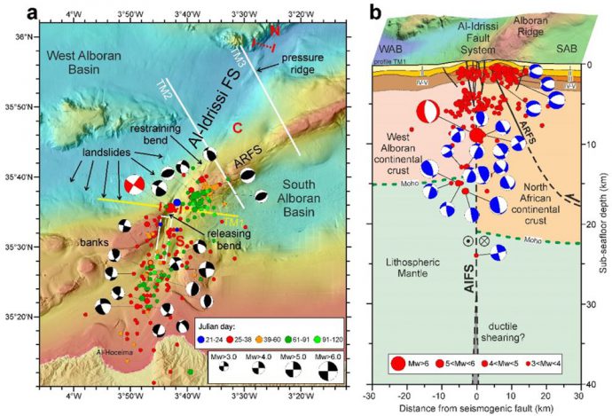
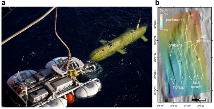
Regarding the methodology, we adopted a multi-scale approach including morphological analyses of shipboard multibeam bathymetry and near bottom bathymetry obtained with Autonomous Underwater Vehicles (AUVs), which allows identifying the geomorphological expression of active faults, such as seafloor ruptures, fault scarps and fault traces. Subsurface multi-channel seismic (MCS) profiles show the geometry and tectonic architecture of the AIFS, a sub-vertical strike-slip fault that roots into the basement. Thus, the AIFS provides a unique model of the inception and growth of a young plate boundary fault system. Over time, accumulation of seismic slip might lead to simpler fault geometry, and eventually longer strike-slip fault zones with the potential for larger magnitude earthquakes. This may be the case for the longest segments of the AIFS, the Central segment, which shows a well-defined Principal Displacement Zone. In contrast, the N and S AIFS segments, which are younger, show discontinuous fault traces and appear to be in an earlier stage of fault development. “Now that we know in detail this growing fault structure, we can establish more precisely the potential seismic evolution of this system,” says the ICM-CSIC researcher.
This study published today (2/09/2019) in Nature Communications, involved researchers from 10 institutions: Institut de Ciències del Mar – CSIC (Barcelona), GEOMAR Helmholtz Centre for Ocean Research (Kiel, Germany), Scripps Institution of Oceanography – UCSD (La Jolla, San Diego, USA), Irish Centre for Research Center in Applied Geosciences (iCRAG) University College Dublin (Dublin, Ireland), Institute of Earth Sciences “Jaume Almera” – CSIC (Barcelona), Institute de Physique du Globe de Paris (France), National Oceanography Center (Southampton, UK), Unitat de Tecnologia Marina-CSIC (Barcelona), Sorbonne Universités – UPMC (Paris, France) and the Institució Catalana de Recerca i Estudis Avançats (ICREA, Barcelona).
Reference:
Gràcia, E., Grevemeyer, I., Bartolomé, R., Perea, H., Martínez-Loriente, S., Gómez de la Peña, L., Villaseñor, A., Klinger, Y., Lo Iacono, C., Diez, S., Calahorrano, A., Camafort, M., Costa, S., D’Acremont, E., Rabaute, A. and Ranero, C.R. (2019). Earthquake crisis unveils the growth of an incipient continental fault system. Nature Communications, 10, 3482. (doi:10.1038/s41467-019-11064-5)


Karim Bouhali | 2022-01-03|16:37 (UTC)
Hi sir i hope you are fine.
please i have a question about figure (2.b), is there any software that can i do depth profile for earthquakes? also how i can do a structural section for my study area.
Thank you so much Sir.
Hector Perea | 2022-01-04|09:39 (UTC)
Dear Karim,
I assume that you are referring to figure 5b.
The profile showing the earthquakes in depth was done using GMT (https://www.generic-mapping-tools.org/). Then the structural section was done and added to the depth profile using a vector edition program as Adobe Ilustrator, Coreldraw or Inkscape. Hope this will help.
Best,
Hector