Guest blog by Christopher B. DuRoss from the U.S. Geological Survey (USGS).
The Great Salt Lake is the largest low-relief, terminal basin in the western United States. In a collaborative effort led by earthquake geologists from the U.S. Geological Survey (USGS) Geologic Hazards Science Center (Golden, Colorado) and marine geophysicists from the USGS Pacific Coastal and Marine Science Center (Santa Cruz, California), we set out to explore whether this shallow, biogenic carbonate basin holds acoustic and sedimentary archives of past earthquake ruptures (DuRoss et al., 2026).
Following the strong (Mw=7.8) Kahramanmaraş earthquake sequence of February 6, 2023 (Fig. 1), within the framework of the collaboration between the Italian Civil Protection Department (DPC) and the Turkish Disaster and Emergency Management Authority (AFAD), a delegation of earthquake geologists, specializing in the collection of coseismic surface effects and representing the DPC’s specific competence centers (INGV, ISPRA, and OGS), conducted a technical mission to Türkiye from May 6 to 13, 2023. This first field survey, carried out in preparation for the subsequent mission planned for October 2023 by the European Task Force “EuQuaGe”, was organized and coordinated by the INGV EMERGEO operational group.
The field survey covered more than 180 km along the central sector of the East Anatolian Fault Zone (Kahramanmaraş‑Pazarcık fault segment; Fig. 1), where coseismic measurements were collected and documented through ground-based photography and drone imagery.
It took a while, but now it’s finally here: Understanding Past Earthquakes, an open access book on the science of identifying large earthquakes. It deals with fundamental questions on large past events: Where did earthquakes occur? How large were they? Which tectonic faults caused them? How strong were the ground motions and where? Six chapters cover the following subjects:
Ou et al. – Earthquake Source Parameters Determination Using Analog Seismic Records
Hough – Macroseismology
Sintubin – Archaeoseismology: Identifying Earthquake Effects in Ancient Sites
Zielke & Klinger – Past Earthquakes in Continental Settings—A Geomorphologic Perspective
Philibosian – Paleoseismology and Paleogeodesy Using Coral Microatolls
Moernaut et al. – Lacustrine Records of Past Seismic Shaking
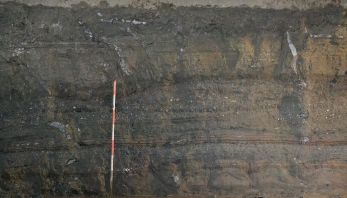
New research challenges the assumption that only strong earthquakes cause liquefaction. Scientists from Poland demonstrated that even low-magnitude shocks (~M3.5) can trigger sediment deformation in water-saturated fine-grained sediments. This finding expands our understanding of seismic activity and its effects on geological structures.
– Focus: Mexican Pacific coast – Subduction Zone – Responsibilities: Field and lab research on coastal geomorphology and tectonic deformation, or/and earthquake, and tsunami geology – Qualifications: Recent Ph.D. in earth sciences, desirable background in either coastal geomorphology, earthquake geology, sedimentology, Quaternary dating, microfossils analytical techniques
At the wonderful Inqua meeting in Rome I saw plenty of presentations and posters with trench pictures. After the first edition in 2022, it’s time to look for the trenchiest trench pictures of 2023. Here’s what you need to do:
Take a break from your too-serious-work
Open the folder with all the field photos
Choose the best/funniest/strangest ones
Smile
Post them on Twitter and tag @GingerFault or send me an email since the bird app is quickly agonizing.
This year categories include “trench with a view”, “the devil is in detail”, “holy cow!”, “trench mindfulness” plus other random stuff which I cannot reveal right now since I still have to figure them out.
Besides the classical paleoseismology studies in today’s list, we have some papers that deal with secondary and cascading effects of earthquakes, such as landslides and diseases, and interesting new findings on short term and long-term tectonic geomorphology. Enjoy reading!
Project EDITH runs under the umbrella of INQUA’s TERPRO commission and the Int’l Focus Group TPPT (Terrestrial Processes Perturbed by Tectonics). EDITH proposes to organize and facilitate annual meetings with a wide range of experts in earthquake geology, paleoseismology, geodesy and tectonic geomorphology to gain a better understanding of the earthquake cycle with the final aim to provide constraints for future new seismic hazard assessment (SHA) geologically-based models. The kickoff meeting has now been scheduled to 14-16 April, 2021 and will be held via Zoom.
On 23 June, 2020, a magnitude 7.4 subduction earthquake struck western Mexico and let the earthquake early warning sirens sound in the capital. Reportedly, ten people lost their lives and thousands of houses were damaged in Oaxaca. Our colleagues Magda Velázquez-Bucio, Sabina Porfido, and Alessandro Michetti have put together a report on the Earthquake Environmental Effects of this event in English and Spanish:
The recent publication of a paper on the Weitin Thrust (Papua New Guinea) by Chen, Milliner and Avouac (Fig. 1) gave me the opportunity to dig out and look back to some notes I wrote few months ago. Chen et al. use optical image correlation to document coseismic surface ruptures along the Weitin Thrust occurred in a Mw 8.0 event in 2000 and in a Mw 7.7 event in 2019. The ruptures overlap along a 20-km long portion, with 3-4 m of slip (Fig. 2).