Dear colleagues,
We would like to bring your attention to a special session at the 2012 Annual Meeting of the Seismological Society of America (17-19 April, 2012, San Diego, California): “Macroseismic Effects in Recent and Ancient Earthquakes and their Relationship to Ground Motion Parameters”. more
Emil Wiechert was born 150 years ago (26 December 1861). He not only invented modern Geophysics and Seismology, but he also had the first chair of Geophysics worldwide (1898 in Göttingen, Germany). Wiechert became famous for his seismograph. Now the Deutsche Post released a special stamp showing Wiechert, his seismograph and the original seismogram of the 1906 San Francisco earthquake as registered in Göttingen, Germany!
more
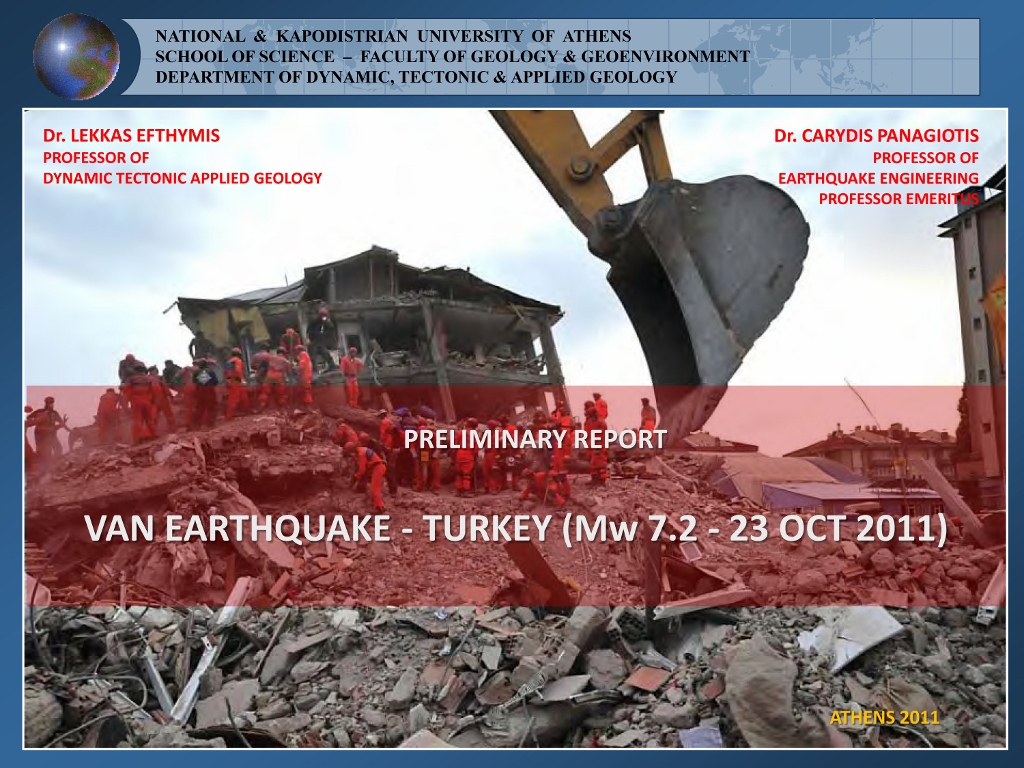 Some preliminary results regarding geological, engineering and social aspects from the Van Mw 7.2 earthquake (23 October 2011) in Eastern Turkey from Prof. Lekkas and Prof. Karydis visit to the site. Have a look at the following link:
http://www.elekkas.gr/el/research/missions/turkey-mission.html
A series of earthquakes has hit Oklahoma, with a M5.6 being the strongest one. The main quake was preceeded by a M4.8 and several smaller ones. A number of aftershocks took place, some of them stronger than M3.0. The epicentre was situated close to Prague about 50 km west of Oklahoma City. All quakes occured in very shallow depth (< 10 km). No injuries have been reported so far, but it seems that some minor damage occured. Quakes of this strength can be felt over hundreds of kilometers in central and eastern US.
more
The Geological Survey of India released a report on earthquake-triggered landslides following the M6.9 Sikkim Earthquake, 18 September 2011. A total of 210 landslides has been reported. That’s earthquake environmental effects!
A special issue on the Christchurch Earthquake has been published in Seismological Research Letters. That’s maybe something I should blog about in greater detail later, so here’s the news and the link only.
more
The Turkey M7.2 earthquake turned out to be a really desastrous event. More than 500 people died, more than 2,000 houses were destroyed. Currently, international aid is reaching the epicentral area. Chris Rowan has a good article on the geological background (an earlier one here), History of Geology discusses the paleoseismicity of that region. The German Aerospace Agency (DLR) prepared some quick response maps for the Van and Ercis areas. Nice work!
more
Update: According to a press release from Bogazici University, intensities reached VIII. They also claim a depth of 5 km only. 138 people died, 350 were wounded and 970 buildings collapsed.
An earthquake with a magnitude of Mw 7.2 (EMSC: Mw 7.3) occured in Eastern Tureky in a depth of 10 – 20 km. The epicentre was situated close to the city of Van. More than 30 houses collapsed according to first reports. Despite only several dozens of people have been confirmed dead until now, the earthquake could have caused hundreds of fatalities. Surprisingly, the quake did neither happen at the North Anatolian Fault Zone nor at the East Anatolian Fault Zone. Those two strike slip systems are considered as the most dangerous faults in Turkey. The Van area lies in a broad zone of convergent movement of the Arabian plate vs. Eurasia, and mapped faults are in concordance with the oblique thrust mechanism observed at the 23 October 2011 event. Convergence rate is in the order of 25 mm/a there. more
Let’s start with some good news: The first two Galileo satellites (Natalia and Thijs) will be launched today from Kourou. It’s a little behind the schedule (6 years) and the entire project has become a little more expensive than previously thought (1,600,000,000 €), but who cares? It will provide 1 m GPS resolution! 1 m!!!
There is one more Archaeopteryx! Really! Soemone who does not want his name to be told handed out the fossil to scientists. After a thoroughly investigation of that great piece of Solnhofen Plattenkalk, the anonymous collector will get back his bird. No, his dinosaur I mean. Ehm, his Archaeopteryx.
Dave Petley reported on a giant landslide in Iceland. It’s expected to have ~1,000,000 m³. See the amazing images, just great.
more
Based on a new inversion of InSAR data, De Natale et al. predicted that the Avezzano and Sulmona tectonic domains, in Central Italy, may anticipate by 15-20 yr the next large earthquake, as a result of stress transfer. Avezzano and Sulmona were razed by a large earthquake in 1915 and 1706, respectively.
Giuseppe De Natale, Bruno Crippa, Claudia Troise and Folco Pingue. Abruzzo, Italy, Earthquakes of April 2009: Heterogeneous Fault-Slip Models and Stress Transfer from Accurate Inversion of ENVISAT-InSAR Data. Bull. Seism. Soc. Am., 101(5), 2340-2354, 2011. DOI: 10.1785/0120100220.
9:00 The second day started with a great keynote, Chris Scholz talked about earthquake triggering and fault synchronization with examples from California and Iceland.
09:45 Next great keynote: Clark Burchfiel on the Wenchuan EQ!
more