I work at the Insubria University in Como, Italy (http://perigeo.uninsubria.it/)
I'm interested in active tectonics and late Quaternary environmental evolution aimed at mitigatin natural hazards.
Moderate to
strong earthquakes commonly produce secondary effects (landslides,
liquefaction, tsunamis), which worsen the impact of the seismic event, both during
the emergency and recovery phases.
Landslides
can be triggered by events of M above 5 or so, and stronger events can produce
thousands of landslides. Landslide inventories were compiled for dozens of
events and the relations between Mw and maximum distance or area affected by
landslides have been analyzed (e.g., Keefer, 1984; Rodriguez et al., 1999). On
the other hand, the total area affected by landslides is one of the metrics
used to assign the ESI intensity (Environmental Seismic Intensity; Michetti et
al., 2007).
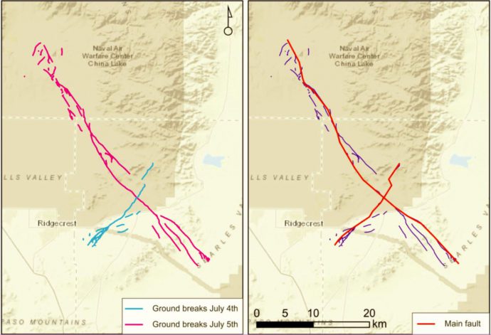
On July 4th and 5th, 2019 two earthquakes (Mw 6.4 and Mw 7.1, respectively) occurred in eastern California and produced distinct surface ruptures. Field surveys started immediately after the first event and, less than two weeks later, a provisional map of surface rupture was compiled and made available to everyone (Contributors from USGS, CGS, UNR, USC, CSUF). I downloaded the map and kmz files of the ruptures from the SCEC response site, which contains tons of fruitful information.
The two strike-slip earthquakes ruptured two perpendicular faults, the first running NE-SW with left-lateral slip and the second running NW-SE with right-lateral slip (Figure 1). The location of the earthquake falls within the Eastern California shear zone, a region of distributed faulting associated with motion across the Pacific-North America plate boundary, and an area of high seismic hazard.
Figure 1. Left: ground breaks caused by the 2 earthquakes. Right: simplified trace, used as main fault.
Ruptures come
with a variable degree of complexity: some sectors show a “simple” single
strand, others show multiple sub-parallel or diverging splays. Distributed
faulting represents displacements occurred off the principal fault and is
generally made up by less continuous ruptures, which can be located tens of
meters to a few kilometers from the principal fault trace. A method to evaluate
the fault displacement hazard has been proposed by Youngs et al. (2003) and
later refined by Petersen et al. (2011); the former study analyzed normal
faults, while the latter analyzed strike-slip faults.
Basically,
the method defines the conditional probability of faulting occurrence as a
function of distance from the principal fault and derives scaling relations
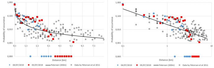
between rupture probability and distance. I applied the same method on the 2019
sequence and compared the output with the results by Petersen; results are
grid-dependent – since available data are still provisional, I used a quite
coarse grid size of 200 m, more detailed studies will come.
Results are in good agreement (Figure 2): the 2019 ruptures show a higher than average rupture probability at 0-2 km from the main fault, but also taper out faster than the previous events.
Figure 2. Comparison between the 2019 events (blue: July 4th; red: July 5th) and data by Petersen et al. (empty circles). The probability of occurrence of faulting is plotted as a function of distance from the main fault (left: linear horizontal axis; right: logarithmic scale).
References:
Petersen, M.
D., et al. (2011). Fault displacement hazard for strike-slip faults. BSSA,
101(2), 805-825.
Youngs, R.
R., et al. (2003). A methodology for probabilistic fault displacement hazard
analysis (PFDHA). Earthquake Spectra, 19(1), 191-219.
On Thursday 28th June, I had the opportunity, together with over 40 students and Early Career Researchers, to attend the full-day summer school organized during the 9th PATA Days Congress in Possidi, Greece.
Gotha speakers gave short lectures on a variety of topics; well, it’s quite strange realizing that behind a book cover or a long list of papers you’ve read there’s a real person with a face, 2 hands and 2 eyes… but that’s what happened to me.
Location, location, location
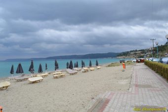
As geoscientists, we all know the importance of a proper location… the Possidi Holiday Resort is just 20 m from the beach! Even the storm Hera did not prevent us to go for a swim.
The Possidi Beach. Photo by Sofia Christoforidou.
The summer school
The first lecturer was Klaus Reicherter, dealing with tsunamis in the Mediterranean and in Greece and highlighting the inherently multidisciplinary nature of such a research.
Tom Rockwell focused on strike-slip fault with worldwide examples – S. Andreas, North Anatolian, Great Sumatra and Dead Sea Faults – and field-based results.
Jim McCalpin spoke about the use of paleoseismology in seismic hazard assessment, giving us a bucket of real-life examples, experiences, good (and less good) practices. And I learned that when building a logic tree, a 5% probability is not denied to (almost) everybody.
Shmulik Marco showed on- and off-fault archaeoseismological evidences and soft-sediment deformations along the Dead Sea Fault. Plus (in my opinion) the best tip of the day: keep good relations with archaeologists, you never know what they will discover under the dirt.
Then, Spyros Pavlides dealt with active faulting in multi-fractured seismic areas, and specifically the Aegean region. Just in case you are wondering if there’s something simple there, ehm… no, you should consider multiple tectonic phases, inherited structures, the presence of normal faulting, subduction zones and volcanic activity all together.
We definitely changed perspective with Manuel Sintubin, speaking about earthquake risk communication and the need to move from a risk message model toward a risk dialogue model; this is a super-important topic not always addressed in the proper way, with possible huge consequences.
Ioannis Papanikolaou spoke about the seismic landscape, extraction of slip rates and fault specific SHA with tens of examples from Greece and Italy and useful tips on advantages and disadvantages of each methodological approach.
Finally, Georgios Syrides gave a lecture on sea level change indicators. Well, I’m very ignorant on this because simply it’s not my bag, so I learned lots of things (bonus: super-cool photos!).
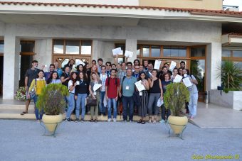
Here’s the PATA team! (yes, I’m quite mad with football and the World Cup was ongoing…)
“He who knows only his own side of the case knows little of that” – John Stuart Mill, On Liberty, 1859
I saw top scientists jump on their seats when other top scientists called “small” a M 6 or “moderate” a M > 7 earthquake. Or when a trench revealing 5 events was called a “short record”. We all have different perspectives, opinions and experiences. And with “we” I mean all of us, from top scientists down to undergraduate students. I think it’s a richness and we should take care of it.
Final remarks: thanks!
The success of the summer school and the whole 9th PATA Days meeting would not have been possible without the contribution and efforts of the Thessaloniki University staff. A big thank to all of you and see you in the next PATA meeting!
Surface faulting is commonly observed after moderate to strong (Mw > 6.0) earthquakes. Beside primary faulting along the seismogenic structure, distributed faulting (DF) may occur in the vicinity of the principal faulting (ANSI/ANS-2.30, 2015). DF may impact wide areas and its forecasting is particularly relevant for the design of critical or distributive infrastructures (e.g., nuclear power plants). DF assessment is currently pursued through probabilistic fault displacement hazard assessment (PFDHA): in this approach, the conditional probability of DF occurrence is computed as a function of magnitude and distance from the primary fault. Empirical regressions were obtained for the different tectonic styles, based on a limited number of case histories (e.g., Youngs et al., 2003 for normal faults). more