A new paper has been recently published in Quaternary International, summarizing the “New developments in onshore paleoseismic methods, and their impact on Quaternary tectonic studies”.
The paper is the result of a cooperative effort (12 authors from 6 different countries and 3 continents) led by Jim McCalpin. Sorry for the paywall, feel free to contact me or the other authors – we will be more than happy to share our work!
The paper has a rather ambitious aim, that is to summarize the new trends in Quaternary tectonics, developed after 2009 – that is the time of publication of the 2nd edition of paleoseismologists’ Holy Book, Paleoseismology.
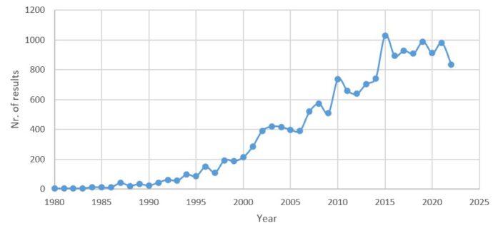
Figure 1 shows the number of results obtained by searching the keyword “paleoseismology” in Google Scholar, per each year in the 1980-2022 interval. Since 2009, the number of papers published on this topic has almost doubled and we’re currently at a rate of almost 1000 papers per year – that’s why we need cliff notes!
The paper covers 4 main thematic areas:
- New and improved methods to map active faults and deformation processes, covering high resolution digital elevation models, measuring deformation in recent earthquakes and field geophysics to image sub-surface related tectonic processes.
- Updates on modern geochronological methods applied to Quaternary studies, covering 14C geochronology, U-series dating, terrestrial cosmogenic nuclides, luminescence geochronology and soil chronosequences.
- New insights into surface ruptures from recent earthquakes, including principal and distributed faulting and photogrammetric trench logging.
- Advances in understanding secondary earthquake effects, such as seismites and liquefaction.
So, where the future will bring us?
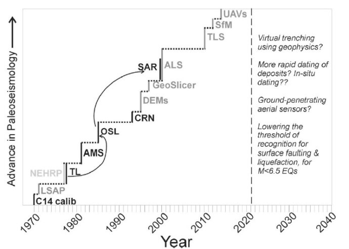
The paper includes a sketch showing that advancement in Paleoseismology reflects the introduction of new technologies in the last decades. In Figure 2, the height of vertical step subjectively represents the relative impact of such advancements (black labels, dating methods; medium gray, remote sensing methods; light gray, institutional changes).
Finally, some thoughts from “paleo(seismicity) to future” are provided.

No Comments
No comments yet.