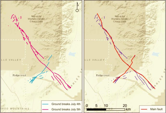
On July 4th and 5th, 2019 two earthquakes (Mw 6.4 and Mw 7.1, respectively) occurred in eastern California and produced distinct surface ruptures. Field surveys started immediately after the first event and, less than two weeks later, a provisional map of surface rupture was compiled and made available to everyone (Contributors from USGS, CGS, UNR, USC, CSUF). I downloaded the map and kmz files of the ruptures from the SCEC response site, which contains tons of fruitful information.
The two strike-slip earthquakes ruptured two perpendicular faults, the first running NE-SW with left-lateral slip and the second running NW-SE with right-lateral slip (Figure 1). The location of the earthquake falls within the Eastern California shear zone, a region of distributed faulting associated with motion across the Pacific-North America plate boundary, and an area of high seismic hazard.

Ruptures come with a variable degree of complexity: some sectors show a “simple” single strand, others show multiple sub-parallel or diverging splays. Distributed faulting represents displacements occurred off the principal fault and is generally made up by less continuous ruptures, which can be located tens of meters to a few kilometers from the principal fault trace. A method to evaluate the fault displacement hazard has been proposed by Youngs et al. (2003) and later refined by Petersen et al. (2011); the former study analyzed normal faults, while the latter analyzed strike-slip faults.
Basically, the method defines the conditional probability of faulting occurrence as a function of distance from the principal fault and derives scaling relations between rupture probability and distance. I applied the same method on the 2019 sequence and compared the output with the results by Petersen; results are grid-dependent – since available data are still provisional, I used a quite coarse grid size of 200 m, more detailed studies will come.
Results are in good agreement (Figure 2): the 2019 ruptures show a higher than average rupture probability at 0-2 km from the main fault, but also taper out faster than the previous events.

References:
Petersen, M. D., et al. (2011). Fault displacement hazard for strike-slip faults. BSSA, 101(2), 805-825.
Youngs, R. R., et al. (2003). A methodology for probabilistic fault displacement hazard analysis (PFDHA). Earthquake Spectra, 19(1), 191-219.


No Comments
No comments yet.