Matthew’s WoGE #345 looked pretty much like an ocean shoreline, but it turned out to be Lake Khanka located at the border of Russia and China. This lake is very shallow but has a large area and it is famous for its biodiversity and strongly influenced by flood events. There have been plenty of beach-WoGEs lately, so I decided to take you to another environment.
The rules:
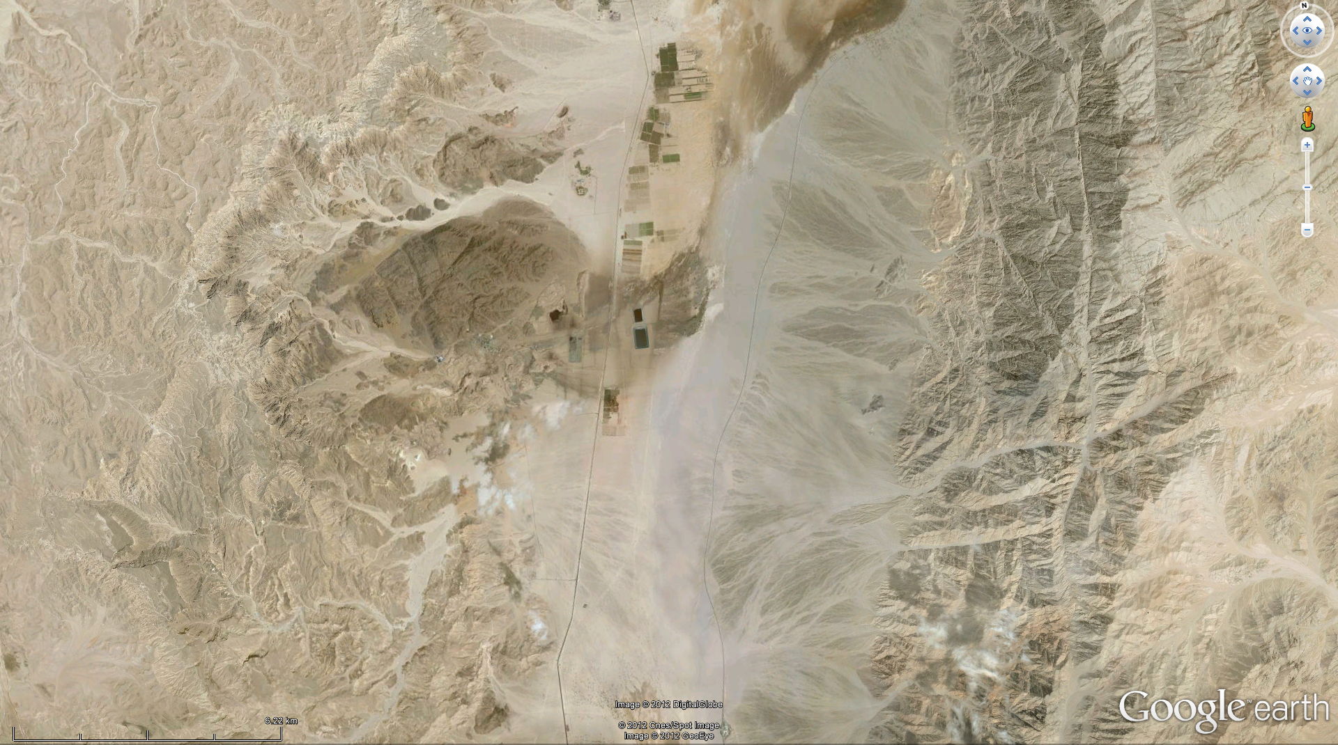
- Find the location of the image below.
- Provide the coordinates in the comments.
- Describe the geological significance of the spot briefly.
- The first one to fulfill theses tasks is the winner.
The benefits:
- Fame.
- Fun.
- The honour of hosting the next WoGE on your blog.
The drawback:
- You might spend some time looking for the right spot instead of writing thesis, paper, proposal.
No Schott rule invoked. If you want to know more, read Felix’ summary.
FJ is right – nine days without solving this is too long. Here are two hints:
- The next capital is 220 km away.
- The next picture is nine times as large.


Luis | 2012-05-18|18:17 (UTC)
I think this one is a WOGM … Where on GoogleMars!
Christoph | 2012-05-19|09:22 (UTC)
Great idea, but that would have been too difficult, even for Ron Schott…
Felix Bossert | 2012-05-19|19:44 (UTC)
But we do have roads and houses. On road ends, so there has to be something which is interesting enough to build a road.
Felix Bossert | 2012-05-19|19:46 (UTC)
ONE road ends (typing error, my “e” is hanging sometimes)
fj | 2012-05-24|21:45 (UTC)
It’s a bit needle-in-haystack style. 😉
Perhaps it is time for a little hint…
Christoph Grützner | 2012-05-25|06:28 (UTC)
Here you go!
Max Arndt | 2012-05-25|14:37 (UTC)
If the scale of 6km on the second image is true, the road is fairly broad.
Max Arndt | 2012-05-25|15:08 (UTC)
It is the Timna National Park in Israel!
This is known as a copper deposit, which has been mined in prehistoric ages already. Copper mineralization occurred in the Early/Middle Cambrian (~525 Ma) Timna Formation, Timna Valley, southern Israel, ~25 km north of Eilat.
Refs: Shlomovitch, N., Bar-Matthews, M., Segev, A., Matthews, A. 1999. Sedimentary and epigenetic copper mineral assemblages in the Cambrian Timna Formation, southern Israel. Isr. J. Earth Sci. 48: 195–208.
Weisgerber, G. (2006), The mineral wealth of ancient Arabia and its use I: Copper mining and smelting at Feinan and Timna – comparison and evaluation of techniques, production, and strategies. Arabian Archaeology and Epigraphy, 17: 1–30. doi: 10.1111/j.1600-0471.2006.00253.x
Christoph | 2012-05-26|19:16 (UTC)
Max, congratulations! WoGE #347 is yours. Where are you going to take us?
Felix Bossert | 2012-05-31|10:38 (UTC)
Woge 347 is at:
http://livin2dmax.wordpress.com/2012/05/29/woge-347/