Yesterday, a magnitude 5.8 earthquake happened near Mineral, Virginia in a depth of 6 km only (37.936°N, 77.933°W) with a thrust faulting mechanism. Media report that the quake was felt as far as Boston and even Canada to the north, but significantly less far away in southern direction. The US East Coast quakes are normally felt in a wide range, since the crust there is old, cold and dense which makes it easy for the seismic waves to propagate. Some damage occurred at the epicentral area, but apparently there were no fatalities. From the earthquake effects (Chimneys collapsed, walls cracked, some springs showed changes) and instrumental measurements an epicentral intensity of VII can be determined.
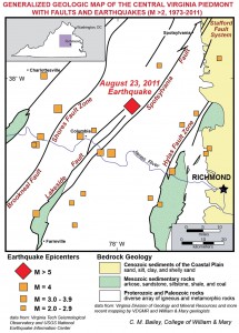
Peak Ground Accelerations reached 0.5 g, which is not too bad. A nearby nuclear power plant was automatically shut down. Chuck Bailey posted a regional geological map, claiming that most likely either Spotsylvania or Lakeside Faults are responsible for the strongest quake in Virginia’s history. The quake was a big surprise to most people – the mountains and faults there are old, very old, and many did not expect a moderate quake to happen there. The Appalachian Mountains were formed during the Paleozoic (Upper Ordovician to Permian, 250 – 460 ma), so why are there earthquakes today, in that “stable” intraplate setting? Two possible explanations are isostatic uplift or far-field stress transfer from the Mid-Atlantic Ridge. Callan Bentley has great post on that, with almost everything to know (also read the comments). USGS produced a nice earthquake poster to be downloaded here.
One great thing is this animation from USArray. Incredible how clearly you can see the waves propagating through the entire US!
Paleoseismology
To earth scientists the occurrence of earthquakes in Virginia is not new. Two events stronger than magnitude 4 happened since the beginning of the instrumental recordings. From weak events it is known that there is certain seismic hazard, although not too much information is available. However, the epicentral region was a colored spot on the seismic hazard map and called the Central Virginia Seismic Zone. Paleoseismological studies are rare in that area – a lot of seismites have been found, but dating back to Ordovician to Permian times, when the Appalachian Orogeny took place. That’s a little too old for us. As far as I know, there haven’t been paleoseismological trenching studies in that area that proved holocene surface-rupturing earthquakes – does anyone know more? The M5.8 earthquake now could possibly have caused a surface rupture, we know that this starts to happen from shallow events around magnitude 5.5. We are looking forward the field surveys there. USGS started to place seismometers in the epicentral region to detect aftershocks, which allows locating the active fault precisely.

What can we say today with the little information available? First of all, that damaging intraplate earthquakes will happen again and again, and that the fact that a structure is old does not necessarily mean it’s inactive. M5.8 is much, but not that much. Stronger events occurred in similar setting before, and they will continue to happen. This should be remembered when critical infrastructure is planned (power plants, refineries etc.). It also becomes perfectly clear that instrumental seismicity does neither tell us about the recurrence intervall of strong events nor about the maximum magnitude when we are talking about areas with low seismicity. You need to look at another timescale. A hundred years is nothing. It’s tens and hundreds of ka. Paleoseismological studies can be conducted to solve that problem, but the investigation of geological settings like that is just starting while the active plate boundaries are comparably well surveyed.
Some nice blogs with articles related to the Virginia event:
- Mountainbeltway
- Ontario Geofish
- Arizona Geology
- State of the planet
- Dan’s Wild Wild Science Journal
- Geology in Motion
- Chuck Bailey
Studies dealing with seismic hazards in that region:
Bollinger, G.A. & Wheeler, R.L., 1983. The Giles County, Virginia, Seismic Zone. Science 219-4588, 1063-1065, DOI: 10.1126/science.219.4588.1063.
Çoruh, C., Bollinger, G.A. & Costain, J.K., 1988. Seismogenic structures in the central Virginia seismic zone. Geology 16-8, 748-751, DOI:10.1130/0091-7613(1988)016<0748:SSITCV>2.3.CO;2.
Johnston, A.C., Reinbold, D.J. & Brewer, S.I., 1985. Seismotectonics of the southern Appalachians. Bulletin of the Seismological Society of America 75-1, 291-312.
Kim, W.Y. & Chapman, M., 2005. The 9 December 2003 Central Virginia Earthquake Sequence: A Compound Earthquake in the Central Virginia Seismic Zone. Bulletin of the Seismological Society of America 95-6, 2428-2445, DOI: 10.1785/0120040207.
Munsey, J.W. & Bollinger, G.A., 1985. Focal mechanism analyses for Virginia earthquakes (1978-1984). Bulletin of the Seismological Society of America 75-6, 1613-1636.


earthquakes today | 2011-09-14|19:26 (UTC)
Hello
It’s a nice article it will help my research.
Thanks