A shallow (12 km) earthquake of magnitude ML3.0 occurred this morning in W Germany near Koblenz in Ochtendung. According to the Geological Survey of Baden Württemberg, the magnitude was ML2.6 only, but the quake was preceded by few minor events (M<2.0) on 9 April and 14 April. Local news (The Rhein Zeitung) report that some people felt the event and that birds were afraid. This earthquake didn’t cause any damage, but it’s interesting in another way: Its epicentre is only 8 km away from the former nuclear power plant (NPP) Mülheim-Kärlich.

Regional Moment Tensors (instrumentally recorded significant earthquakes), data from EMSC-CSEM – http://static2.emsc.eu/Images/EVID/31/313/313065/313065.EMMA.jpg

Seismograms of the ML3.0 earthquake in Ochtendung. Data source: Geological Survey of Rhenania Palatinate – http://www.lgrb.uni-freiburg.de/led_pool/images/130418_0337.seis.png)
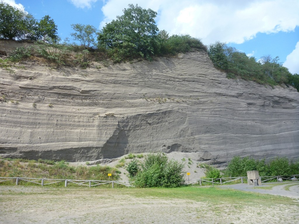
This NPP was finished in 1986 but taken offline already in 1988. It turned out that the building permit should have been re-evaluated after it became clear that the site was located in an area of increased seismic hazard, the Neuwieder Becken (Hinzen and Reamer, 2007). The NPP Mülheim-Kärlich is currently being dismantled. However, some people also thought that it would be kind of, let’s say: provocative to built a NPP less than 20 km away from an active volcano. Yes, there are active volcanoes in Germany! The “Laacher See” volcano is located ~17 km to the west of Mülheim-Kärlich and had its last eruption 12,900 years cal BP (Litt et al., 2003). This eruption was so strong that the ash layer is used as a Holocene marker horizon even in Sweden and Poland. The ash deposits are as thick as 50 m close to the volcano and still around 10 m thick in up to 5 km distance from the eruption. A total of ~6 km³ of material has been erupted and dammed the River Rhine downstream of Mülheim-Kärlich, which lead to the creation of a huge lake that breached soon. Here’s an image of the ash deposits at the famous Wingertsbergwand:
The following map illustrates the location of the NPP and the Laacher See volcano:
So, it’s not like the volcano is about to erupt. Actually, it might never erupt again, but chances are it does. Furthermore, the M3.0 earthquake is not much more than a very weak tremblor that wasn’t felt by more than 100 people and which is far too weak to cause any damage to a structure as solid as I expect a NPP to be. It’s just, you know, one needs to be very, very careful when it comes to NPPs. The public doesn’t like sentences that conatin “NPP” and “seismic hazard”. And the public is right in this case.
References:
- Hinzen, K.-G. and Reamer, S. K., 2007. Seismicity, seismotectonics, and seismic hazard in the northern Rhine area. GSA Special Papers 425, 225-242, DOI:10.1130/2007.2425(15).
- Litt, T., Schmincke, H. U. and Kromer, B., 2003. Environmental response to climatic and volcanic events in central Europe during the Weichselian Lateglacial. Quaternary Science Reviews, 22 (1), 7-32, DOI:10.1016/S0277-3791(02)00180-4.
Update:
In an earlier version I wrote Geological Survey of Rhenania Palatinate, but of course its the one of Baden Württemberg. Its not Rhenania Palatinate but Rhineland-Palatinate, by the way. Thanks to Andi!


No Comments
No comments yet.