Text: Gösta Hoffmann with contributions by Michaela Falkenroth, Valeska Decker, Bastian Schneider and Christoph Grützner
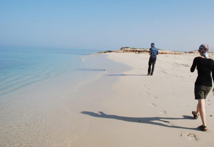
“The beaches in Oman are pristine.” What sounds like an introductory sentence to a tourist brochure has scientific significance. Natural conditions without anthropogenic overprint are characteristic for vast stretches along the 1700 km coastline of Oman from the Strait of Hormuz in the north to the border of Yemen in the south. This situation allows geological research addressing Quaternary sea-level change on various timescales spanning from minutes to millennia. Over the last couple of years, we carried out research funded by the Omani Government and the German Research Foundation (DFG). Our findings are currently published in a series of papers (Schneider et al. 2018; Ermertz et al. 2019; Falkenroth et al. 2019, subm.; Hoffmann et al. 2020a, b) and are briefly summarised here.
Geologic setting
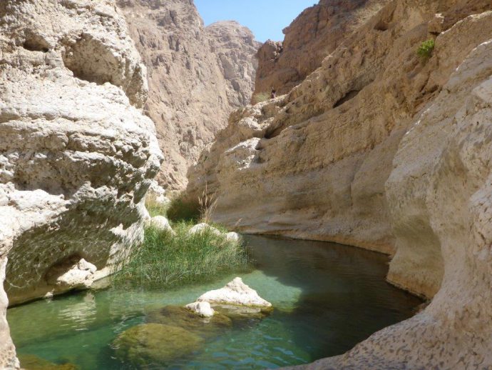
The study area is characterised by a diverse geological history, differing morphology and variable climate settings. The northern coastline of Oman formed in the distal part of a huge alluvial fan complex. The coastline is therefore dominated by long, sandy beaches. The apexes of the fans are located at the foot of the Hajar Mountains. This arched mountain chain dominates northern Oman. Currently, the study area is characterised by semi-arid to arid conditions with precipitation values generally below 100 mm per year. The highest mountain peaks are 3 000 m in elevation. Here, precipitation values are higher and currently up to 320 mm per year are recorded. Variable climate in the Quaternary, with alternating chemical and physical weathering, resulted in intensive erosion. As a consequence, the scenery in the mountains is spectacular, with erosional landforms, including deeply incised river systems, locally known as wadis. The rock sequence exposed in these wadis reveals a complex geological history, starting in the Precambrian. Continued sedimentation is encountered with the opening of the Tethys Ocean in the Permian. The Permian-Mesozoic sequence is dominated by limestone that formed on a carbonate platform along the passive margin of the ocean. The sequence is overlain by two nappes of which the upper one is world-famous: The Semail Ophiolite. This remnant of the ocean floor was obducted in a geological accident during the Upper Cretaceous. The Hajar Mountains, including the ophiolite and overlying Paleogene carbonates, are characteristic for the coastal area of eastern Oman. Here rocky cliff sections alternate with small pocket beaches.
Tectonics & earthquakes & tsunamis
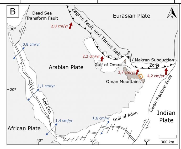
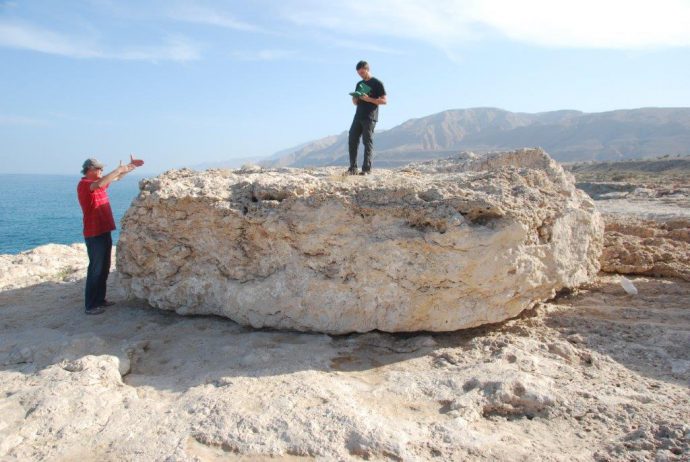
Oman is located on the Arabian Plate, which is rotating counter clockwise towards the Eurasian Plate. In between these two lies the Makran Subduction Zone with a hazard potential that is best described as enigmatic. The seismicity is concentrated along the eastern part of the subduction zone, whereas the western part is seismically quiet, which hampers the assessment of risk. The last severe earthquake that struck here resulted in a tsunami that affected the coastlines on 27th November 1945. As Oman’s coastline was sheltered by India from the major tsunami event in 2004 and the 1945 event happened more than 3 generations ago, the awareness of risk is low. One main goal of our research was to find sedimentological evidence of past tsunami events. We mapped coastal sediments by means of classic geological fieldwork, with a special emphasis on sediments indicating marine facies. The general assumption was that an extreme-wave event reworks nearshore, intertidal and beach sediments and redeposits them inland on elevations above mean sea level. The processes responsible for the wave event can be either a storm surge or a tsunami. It remains a challenging task to decipher these processes by sedimentological criteria. We identified sandy washover deposits as well as block and boulder ridges located above mean sea level.
Field work on tsunami sediments
We applied differential GPS measurements to reveal the exact elevation of the deposits and used terrestrial laser scanning and drone surveys to precisely map the block and boulders (Schneider et al. 2018). The largest boulder has a mass of 120.5 tons. We conclude on the timing of the events by radiocarbon dating of marine organism attached to the blocks and boulders or incorporated in the washover deposits (Hoffmann et al. 2020b). Furthermore, optically stimulated luminescence dating (OSL) was applied to washover deposits and archaeological remains were identified that testify for devastating waves. Pottery sherds within these deposits could be attributed to distinct cultural groups and time periods. Taken the archaeological evidence, radiocarbon and OSL dating together, we conclude that a severe tsunami event must have occurred ca 1000 years ago. The location of the deposits relative to the recent coastline indicates waves exceeding the ones observed during the tsunami event in 1945 and also during major tropical cyclones in the recent past. The consequences of a tsunami of such height hitting today’s capital city Muscat would be severe. The main problem is seen in the population density along the coastline of the capital area. On top of that critical infrastructure, including refineries, desalination, gas liquefaction plants as well as important ministry buildings are located within potential inundation areas (Schneider et al. 2016).
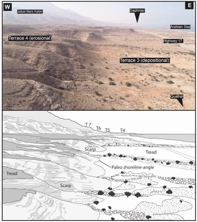
Field work on coastal uplift
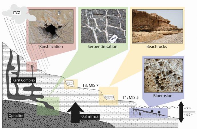
The second main goal was to quantify apparent uplift and associated neotectonic movements along a 72 km coastal stretch at the eastern shores of Oman where the Hajar Mountains reach the Indian Ocean. The processes responsible for this crustal deformation are not obvious as the study site is located along the passive continental margin of the Arabian Peninsula. The coastal scenery is an outstanding example of raised shorelines. At least nine coastal terraces form a staircase from the recent sea level up to elevations of more than 400 m. We hypothesised that the terraces can be used to quantify uplift rates. We carried out geological mapping with an emphasis on paleo-beach deposits. Especially cemented beach rocks proved to be erosion resistant and served as an ideal proxy to reveal paleo sea-level. Michaela showed results of thin section analyses in combination with detailed facies analyses in her master thesis, which were subsequently published (Falkenroth et al. 2019). Basti analysed digital elevation models from TanDEMX data, which were used to map the shoreline angles. The biggest challenge was the dating of the terraces. We finally managed in collaboration with colleagues from Cologne University, who performed cosmogenic nuclide dating. As a result, we are able to demonstrate that uplift rates are less than a millimetre per year and that the uplift is spatially and temporarily differential. This caused brittle deformation and Alina concluded in her MSc thesis that the ancient city of Qalhat – located at the southern termination of the uplifting block – was most probably destroyed by an earthquake some 500 years ago (Ermertz et al. 2019). The processes responsible for the uplift are a combination of karst- and serpentinisation-driven isostasy and forebulge movement caused by the subduction at the MSZ. The southern termination of uplift is confined by the Qalhat Fault. The city of Sur is located south of the fault. Here, we identified a coastal notch that fringes a lagoon. The notch is associated to marine isotope stage 5 and in an elevation of 3.7 m msl. The same coastline is some 50 m higher north of the fault. By studying bio-erosional and -constructional organisms including their traces, Michaela and the MSc students Silja, Mirjam, and Hassan were able to demonstrate decimetre scale sea-level oscillation during notch formation (Falkenroth et al. subm.).
We look back on several years of interesting and productive fieldwork along the coastline of Oman. Work is in progress as Valeska is digging out paleo-mangrove forests to quantify Holocene climate changes.
Also read the press releases about our tsunami research here:
- Uni Bonn (English): https://www.uni-bonn.de/news/289-2019
- Uni Bonn (German): https://www.uni-bonn.de/neues/289-2019
- Uni Jena (English): https://www.uni-jena.de/en/191120_Omantsunami_en.html
- Uni Jena (German): https://www.uni-jena.de/191120_Omantsunami.html
References
- Ermertz, A.M., Kázmér, M., Schneider, B., Adolphs, S.K., Falkenroth, M., & Hoffmann, G. (2019). Geoarchaeological Evidence for the Decline of the Medieval City of Qalhat, Oman. – Open Quaternary. 5: 8, pp. 1–14. https://doi.org/10.5334/oq.56
- Falkenroth, M., Adolphs, S., Cahnbley, M., Bagci, H., Kázmér, M., & Hoffmann, G. (submitted). Biological Indicators Reveal Small-Scale Sea-Level Variability During MIS 5e (Sur, Sultanate of Oman). – Open Quaternary.
- Falkenroth, M., Schneider, B., & Hoffmann, G. (2019). Beachrock as sea-level indicator – a case study from the coastline of Oman (Northern Indian Ocean). – Quaternary Science Reviews, 206: 81-98.
- Hoffmann, G., Grützner, C., Schneider, B., Preusser, F., & Reicherter, K. (in press). Holocene tsunamigenic earthquakes in the western Makran Subduction Zone. – Marine Geology. doi: 10.1016/j.margeo.2019.106068.
- Hoffmann, G., Schneider, B., Mechernich, S. Falkenroth, M., Ermertz, A., Dunai, T., & Preusser, F. (2020). Quaternary uplift along a passive continental margin (Oman, Indian Ocean). – Geomorphology 350. https://doi.org/10.1016/j.geomorph.2019.106870
- Schneider, B., Hoffmann, G., Grade, J., & Falkenroth, M. (2018). Tsunami and storm sediments in Oman: Characterizing extreme wave deposits using terrestrial laser scanning. – Journal of Coastal Conservation. – https://doi.org/10.1007/s11852-018-0663-4.
- Schneider, B., Hoffmann, G., & Reicherter, K. (2016). Scenario-based tsunami risk assessment using a static flooding approach and high resolution digital elevation data: An example from Muscat in Oman. – Global and Planetary Change. 139: 183–194.


Huge tsunami hit Oman 1,000 years ago – GUtech | 2019-11-26|05:52 (UTC)
[…] 15-meter high waves that pushed boulders the weight of a Leopard tank inland: This is more or less how one can imagine the tsunami that hit the coast of today’s Sultanate of Oman about 1,000 years ago, as concluded by the recent study. The findings show how urgently the region needs a well-functioning early warning system. But even then, coastal residents would have a maximum of 30 minutes to get to safety in a similar catastrophe. The study will be published in the journal “Marine Geology”, but is already available online http://paleoseismicity.org/quaternary-sea-level-change-along-the-coastline-of-oman/. […]