Hungary plans to build a new nuclear power plant (NPP) at the banks of the Danube near Paks, where another NPP is already running for several decades. An interesting story is currently unfolding around the geological site conditions, and this story includes paleoseismology. In short, the Austrians and external experts argue the planned NPP Paks II will sit on a capable fault, while the Hungarians say there is a fault, but it can’t rupture the surface. Actually, it’s a bit more complicated…
Old and new NPP Paks
Almost half of Hungary’s electricity comes from the NPP Paks, situated at the Danube, some 100 km south of Budapest. This plant is in use since the 1980s. In order to secure future electricity generation, Hungary wants new reactor blocks (Paks II) to be constructed at Paks by Rosatom. Of course, the application for the construction license needed to include a detailed geological study of the site.
The geological report
The geological study was run by Hungarian geologists and included extensive geophysical surveys, seismicity data, morphological analyses, drillings, outcrop studies, and paleoseismological work. Its results were used in the site licence application to prove that the site is safe from a geological point of view. This also included seismic hazard. Parts of the report on the geological work were publicly available (in Hungarian) and caught the attention of the Environment Agency Austria (EAA). They suspected that not all available geological data supported the evaluation by the Hungarian authorities that the site is safe.
Review by Decker & Hintersberger
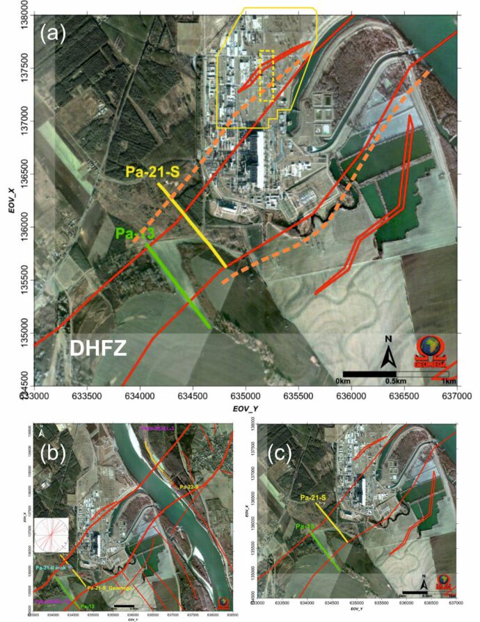
The EAA asked Kurt Decker & Esther Hintersberger to review the geological data. Their extensive report (in the following: DH21) has been published here as a PDF. (I was one of the reviewers of this report.) DH21 found several problems. The Hungarian geologists did a great job documenting evidence for recent motion on the left-lateral Dunaszentgyörgy-Harta fault zone and on nearby faults. A seismics survey at the Paks site showed evidence for several fault strands affecting Quaternary sediments in a more than 600 m wide zone, most likely a flower structure.
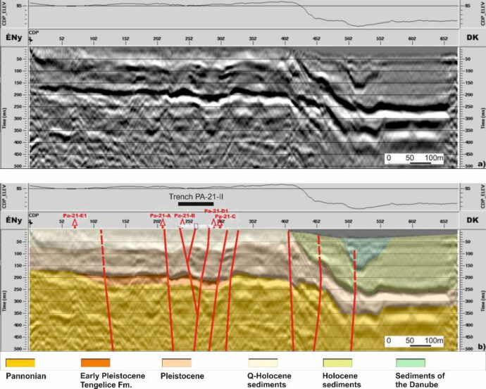
A 81 m-long paleoseismological trench was excavated, which did not cover all the faults detected in the seismic data. In the trench, the geologists found fractures and other deformation features, dated to ca. 20-19 ka. While the site safety report considered these features as not indicative for fault capability, DH21 interpreted this as clear evidence for Late Quaternary surface offsets of the fault.
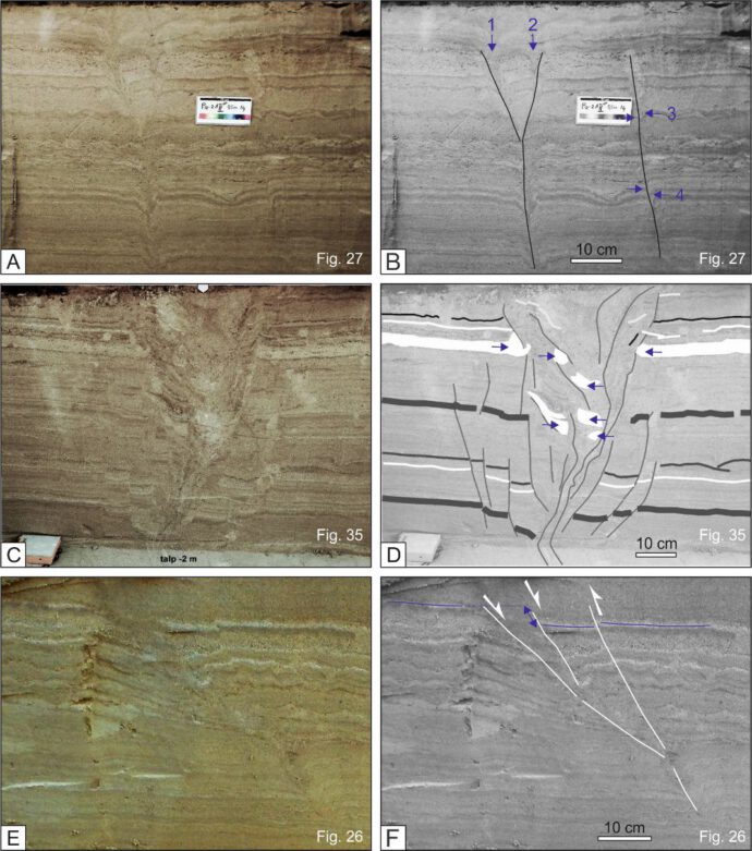
Other observations include repeated liquefaction and 0.6 m fault offsets younger than 8 ka observed along highway outcrops ca. 10 km away from the NPP, and liquefaction features in the immediate vicinity of Paks. The main question is: Why were all these data not properly included in the site safety report? Why was there no extensive paleoseismological campaign to trench the entire fault width beneath Paks (80 out of >600 m)? The Dunaszentgyörgy-Harta fault is part of the Mid Hungarian Shear zone, a ca. 350 km long fault system that was active in the Tertiary – how much can one say about this fault from a single trench site? What data was used to justify the assertion that the fault can’t reasonably be expected to offset the surface? There’s no doubt at all that Paks sits right on this huge fault, but the question of course is if it is active and capable sensu IAEA.
Bilateral talks
The Austrians published the DH21 report, which includes eight questions to the Hungarian Atomic Energy Authority (HAEA). A paper by Katona et al. (2021) presents seismotectonic a method for modelling the Fault Displacement Hazard based on Probabilistic Seismic Hazard Analysis (PSHA), which seemed to be a justification of the site licencing. Still, open questions remained… The Hungarians invited the Austrian delegation to discuss the issues raised by DH21 in a bilateral workshop. The HAEA press release on this workshop can be found here, and it is worth a read.
Conclusion
This is an interesting paleoseismology problem, but not only that. It touches all aspects of the question: How do we prove that a fault is capable? It has, I think, relevance for a couple of projects around the world. Comments and sharing welcome!


Carlos Costa | 2022-04-25|17:25 (UTC)
Dear Christoph,
many thanks for posting this interesting case, very nicely documented and showcased by the DH21 report.
According to my experience with siting projects for nuclear installation, it happens often that because the consultant push to get the site licensee and to upgrade the project into further stages, geological data are not fully considered or they do it sparingly in the SSR.
After reading the outcome of the bilateral meeting expert, I see that despite the strong statement raised in DH21 (the report does not meet good standard scientific practices and does not meet as well HAEA exclusion criteria), this agency concluded that “no permanent surface displacement in the fault segment is expected.”
This highlights your challenging question (How do we prove that a fault is capable?).
In my view, the need of regulatory agencies to fit into regulatory normative the fault-related hazard, led to a myriad of definitions (sometimes misleading) of active, capable faults, etc. I think that fault activity an fault hazard may not be equal concepts, particularly in slowly deforming regions. Thus, the acceptable fault-related hazard that we should assess varies from case to case, and that should be agreed by all the partners while defining the terms of references.
I read that HAEA definition of capable fault is inspired in IAEA SSG-9, but even more generic “: (a) Data indicate a recurring nature of movements, significant deformations or dislocations, or all of the three, within such a period of time that does not allow to exclude that the next displacement of a fault terminates at the surface or close to the surface.” Meaning, a big umbrella that leaves open the scales of elapsed time, recurrence time and fault slip…… So, standing on that and giving the currently available data on the project site, HAEA may claim they are accomplishing their duties and the decision of capable or not may fall on expert judgment, PFDHA, or others.
WENRA definition of capable fault is way different
I do not know the details, but perhaps a joint agreement between both agencies on how a definition of capable fault should be addressed (necessary data, acceptable hazard, etc, including probabilistic or deterministic approaches -WENRA seems to adopt this last one-) may help to work out this or future disputes.
Best
Carlos