In a recently published open access paper in TECTONICS, Zebari et al. report for the first time fault slip rates from Iraqi Kurdistan in the NW Zagros Fold-Thrust Belt. This area is challenging when it comes to narrowing down the distribution of S-N shortening and the associated fault slip rates, because in general, faults don’t reach the surface there. For this reason, we used a proxy: we dated uplifted river terraces with stimulated luminescence and used kinematic modelling of the Zagros fold belt. With this approach we can show that slip rate of the Mountain Front Fault is about 1.5 mm/a. Detachment folds take up another ~1.6 mm/a.
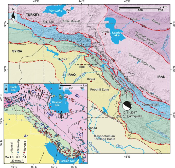
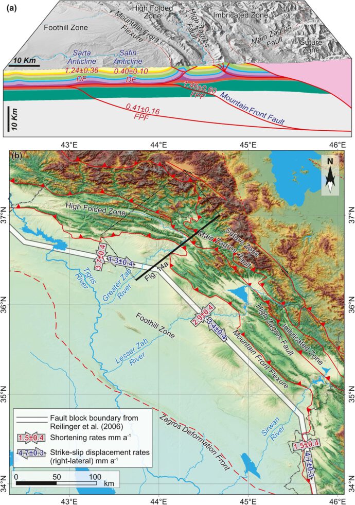
The Zagros is a huge Fold-Thrust Belt that reaches from the Strait of Hormuz in the SE all the way up to Turkey in the NW. It has an impressive topographic relief and a rather complicated geometry. Several more or less parallel thrust faults accommodate about 5-10 mm/a of belt-perpendicular shortening that is due to the N-S Arabia-Eurasia convergence, plus there’s a significant amount of right-lat strike slip (Fig. 1). Anticlines grow in front of the mountain front, and they are extremely beautiful.
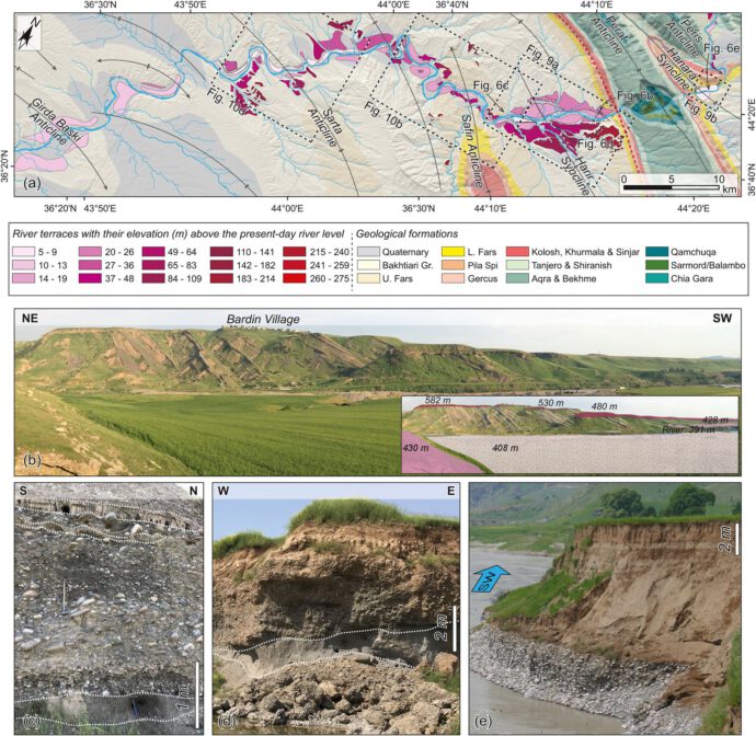
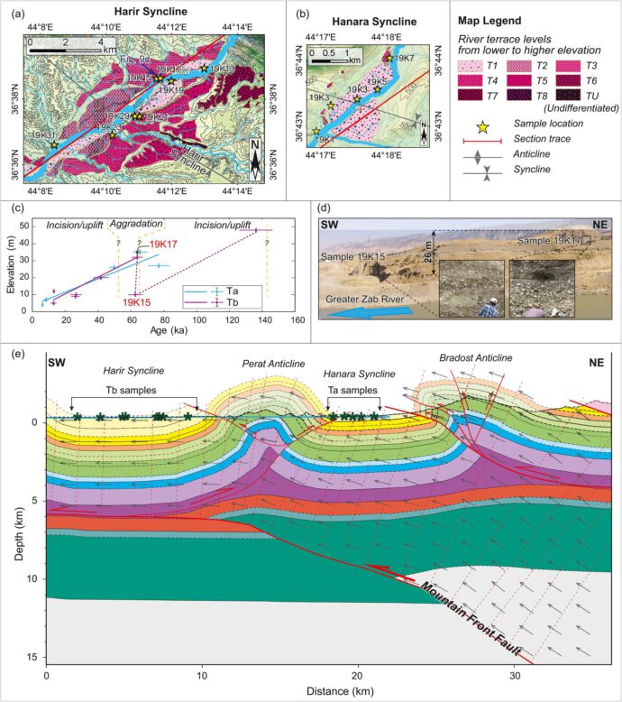
In order to get the slip rates from the thrust faults that take up the shortening, we looked into abandoned river terraces along the Greater Zab River. The idea is that these terraces record the uplift caused by the faults at depth (Fig. 2). We measured the elevation of several generations of terraces from DEMs and in the field and took luminescence samples to determine their ages (Figs. 3, 4).
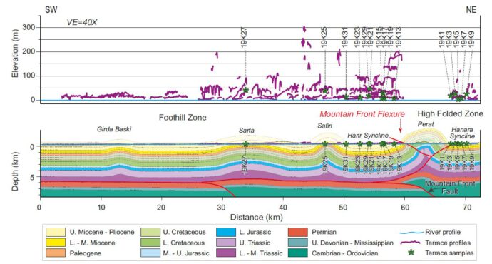
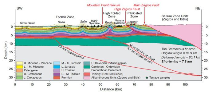
These data allowed us to calculate uplift rates – but didn’t we want to know about fault slip rates? For this, we need additional information on the fault geometry. Kinematic modelling along structural cross-sections helped us to solve this (Fig. 5). We used field observations and published data to construct the cross-sections and to convert the uplift rates into fault slip rates. We show that the Mountain Front Fault has a slip rate of about 1.5 mm/a. Another, more external basement fault further to the SW accommodates less than 0.41 mm/a, and horizontal slip rates related to detachment folding of two anticlines within the Zagros Foothills are ca. 0.40 mm/a and 1.24 mm/a, respectively (Fig. 6).
While the main result of our study is the information on the slip distribution and the associated fault slip rates, we also provide a work flow that can be used elsewhere in the Zagros. We concentrated on the Greater Zab River, but other rivers that cross the mountain range have beautiful terraces, too. In the future we might be able to also better understand the along-strike variation of slip rates and the underlying processes controlling them.
Reference and further reading
- Reilinger, R., McClusky, S., Vernant, P., Lawrence, S., Ergintav, S., Cakmak, R., et al. (2006). GPS constraints on continental deformation in the Africa-Arabia-Eurasia continental collision zone and implications for the dynamics of plate interactions. Journal of Geophysical Research: Solid Earth, 111(5).
- Zebari, M., Preusser, F., Grützner, C., Navabpour, P. and Ustaszewski, K. (2021): Late Pleistocene-Holocene slip rates in the Northwestern Zagros Mountains (Kurdistan Region of Iraq) derived from luminescence dating of river terraces and structural modeling. Tectonics, 40, e2020TC006565.
- Zebari, M., Balling, P., Grützner, C., Navabpour, P., Witte, J., & Ustaszewski, K. (2020). Structural style of the NW Zagros Mountains and the role of basement thrusting for its Mountain Front Flexure, Kurdistan Region of Iraq. Journal of Structural Geology, 141, 104206. https://doi.org/10.1016/j.jsg.2020.104206.
- Zebari, M., Grützner, C., Navabpour, P., & Ustaszewski, K. (2019). Relative timing of uplift along the Zagros Mountain Front Flexure (Kurdistan Region of Iraq): Constrained by geomorphic indices and landscape evolution modeling. Solid Earth, 10(3), 663–682. https://doi.org/10.5194/se-10-663-2019.
- Zebari, M. M., & Burberry, C. M. (2015). 4-D evolution of anticlines and implications for hydrocarbon exploration within the Zagros Fold-Thrust Belt, Kurdistan Region, Iraq. GeoArabia, 20(1), 161–188.
- Zebari, M., Preusser, F., Grützner, C., Navabpour, P., & Ustaszewski, K. (2021). Luminescence dating of river terraces along the banks ofthe greater Zab River in the northwestern Zagros mountains in Kurdistan region of Iraq. PANGAEA. https://doi.pangaea.de/10.1594/PANGAEA.933900


No Comments
No comments yet.