The Bolivian Amazon is a vast plain with almost zero topography. It hosts a huge and dynamic river system on the east side of the Andes. So far, little was known about the active tectonics of the area. In a new paper, Umberto Lombardo and I show that there are active faults parallel to the Andes, and also perpendicular to the mountain front. We used the TanDEM-X DEM and geomorphological analyses of the fluvial system to investigate the faults and their impact on river dynamics. We show that in such a low-relief setting, dip-slip earthquakes can catastrophically change river courses. If you don’t have the time to read the full paper, here’s a short summary.
General setting
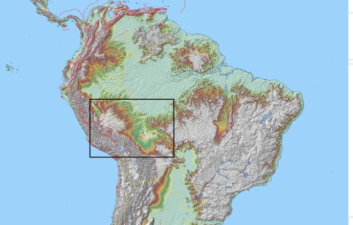
The Bolivian Amazon foreland basin is controlled by the sediment input from the Andes and their topographic load, by the basinal uplift in the forebulge, and by the uplifting Fitzcarrald Arch in the north (Fig. 1). Here, the foredeep basin is up to 3 km deep and the forebulge is ca. 300 km away from the mountain front. The Llanos de Moxos is a seasonally flooded savannah that covers the basin.
Click on the button to load the content from earthengine.google.com.
Fault scarps in the DEM
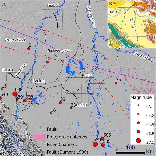
On the DEM we found three fault scarps that parallel the Andes (faults 1-3 in Fig. 2), at a distance of 80-150 km from the main deformation front on their eastern side. Additionally, two faults strike oblique and perpendicular to the Andes, respectively. They are clearly predominantly dip-slip and show tilted blocks (Fig. 3).
We measured the offset distribution along strike of each fault and found that have vertical displacements between 3-20 m. In general, they show a rather conventional offset distribution, although sometimes the offset is a little bit skewed (Fig. 4).
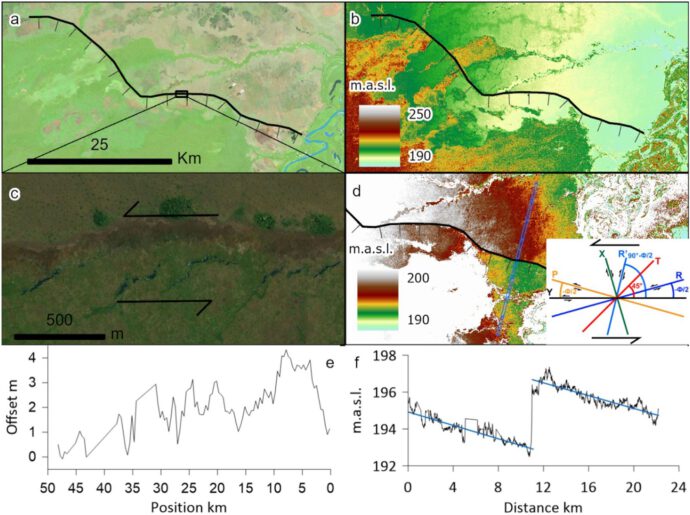
At least one fault shows evidence for a significant left-lateral component of slip where its trace is oblique to the trend of the Andes (Fig. 4). The faults are up to 50 km long. Thus, the observed offsets of around 4 m could correspond to one big earthquake (single-event scarps) in the order of M7. It is clear that the larger offsets observed on some faults must be multi-EQ.
Tectonic imprint on the fluvial system
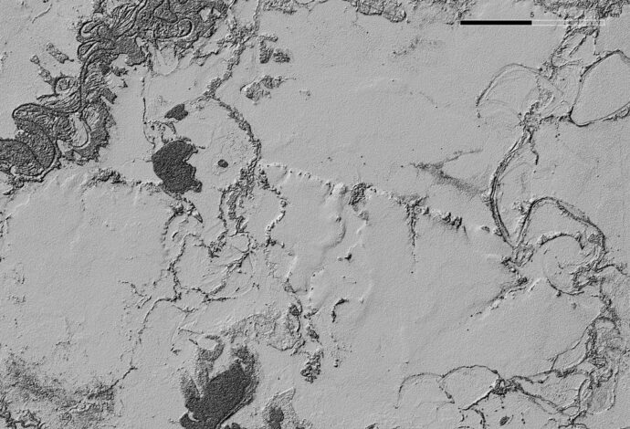
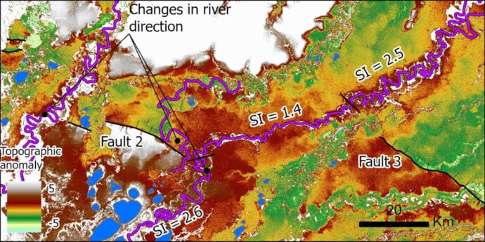
Not only do we see the fault scarps, but it is also clear that the river system has recorded the vertical motion of the fault blocks. We found paleo-river courses that have fallen dry; their old riverbeds now show an inverse slope (Fig. 5). In addition, lakes have formed and the rivers’ sinuosity changes significantly where they cross the faults (Fig. 6).
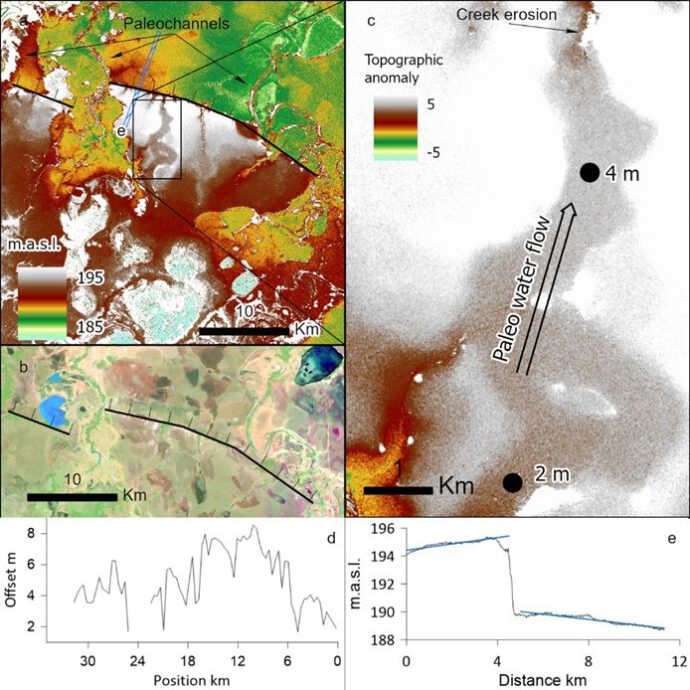
This observation has an important implication: When the faults slip in a strong earthquake with a few metres of vertical slip, entire river systems in this low-relief area may be diverted and forced to find a new riverbed. This would have dramatic consequences for the local communities.
Reverse or normal faulting?
The elephant in the room is the fault mechanism. Are we looking at normal fault or at reverse faults? In the case of normal faulting, extension on top of the forebulge would be a plausible mechanism, at least for the faults that strike parallel to the Andes (poorly-drawn Figure 8). The faults running more in N-S direction could be accommodating a NW-directed down-bend of the crust caused by the Fitzcarrald Arch. Arguments in favour of this interpretation are the large distance from the main Andean deformation front and the fact that we observe a graben-like geometry at least in one case. Against this interpretation stands that the published locations of the forebulge do not really fit the location of the faults (Fig. 2).
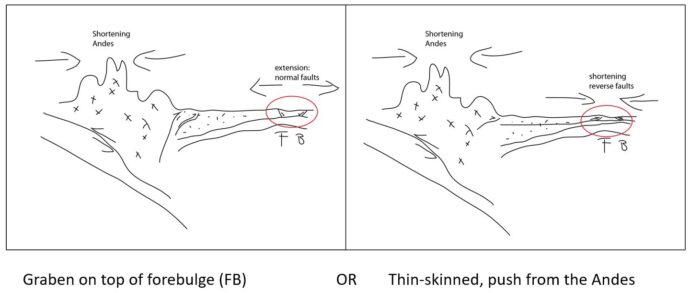
Reverse faulting in a thin-skinned style could be the result of the push from the Andes (Fig. 8), at least for the faults parallel to the mountain range. Arguments in favour of this interpretation are that the faults do not sit on top of the forebulge and that the overall stress field is ~SW-NE compressional. However, there are very few geodetic data available for the area and regional deviations from the stress field are not well known. The sinistral component of slip observed along one fault could also indicate thrusting. An argument against this view is the fact that the faults are pretty far away from the Andes…
Conclusions
The fault mechanism could be determined by field work on those faults, especially by paleoseismological excavations or by geophysical surveys. In any case, we found a number of faults that clearly affect the regional drainage, and which have left an imprint in the landscape. The faults must be active, because all possible drivers are active processes, and because such a highly dynamic river system would quickly remove their surface expression. We don’t know when the faults had their last big quakes as this study was entirely based on remote sensing. Although Umberto has spent a long time in that area, field studies on those faults yet need to be undertaken… Check out Umberto’s blog for more great stuff on the Amazon: http://umba-moxos.blogspot.com/!
Reference
Lombardo, U., & Grützner, C. (2021). Tectonic geomorphology and active faults in the Bolivian Amazon. Global and Planetary Change, 103544.


No Comments
No comments yet.