
Guest blog by Christopher B. DuRoss from the U.S. Geological Survey (USGS).
The Great Salt Lake is the largest low-relief, terminal basin in the western United States. In a collaborative effort led by earthquake geologists from the U.S. Geological Survey (USGS) Geologic Hazards Science Center (Golden, Colorado) and marine geophysicists from the USGS Pacific Coastal and Marine Science Center (Santa Cruz, California), we set out to explore whether this shallow, biogenic carbonate basin holds acoustic and sedimentary archives of past earthquake ruptures (DuRoss et al., 2026).
Background
The Great Salt Lake is a large (≥2500 km²) and shallow (≤15 m) lake occupying a low-relief terminal basin with slopes typically ≤1°. The lake is the remnant of Lake Bonneville, which regressed to its current level during the warm and dry climate after ~13 ka (Oviatt et al., 2021). The basin is in the eastern portion of the Basin and Range extensional province of the western United States, west of the Wasatch fault zone (WFZ) and in the hanging wall of the sublacustrine Great Salt Lake fault (GSLF) (Figure 1).
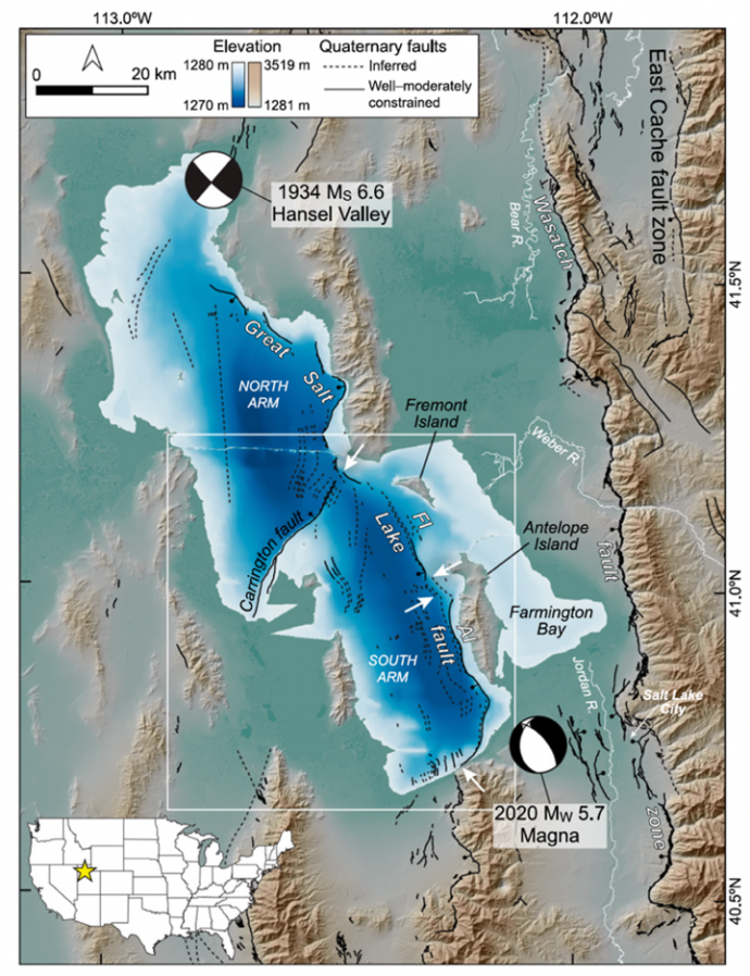
The Great Salt Lake has unique limnogeologic characteristics. High evaporation rates yield hypersaline conditions (Balch et al., 2005), and sediment input into the lake is principally via brine shrimp (genus Artemia) fecal pellet production and carbonate precipitation (Eardley, 1938). Previous near-surface cores show that lake sediments mostly consist of laminated aragonitic brine-shrimp-fecal-pellet mud (Spencer et al., 1984; Oviatt et al., 2015). Although the lake has been the subject of intense sedimentologic, geomorphologic, geochronologic, hydrologic, climatic, biologic, and seismic scrutiny, comparably less research has been focused on the lake’s paleoseismic record (Dinter and Pechmann, 2005, 2014; Wong et al., 2016).
New data
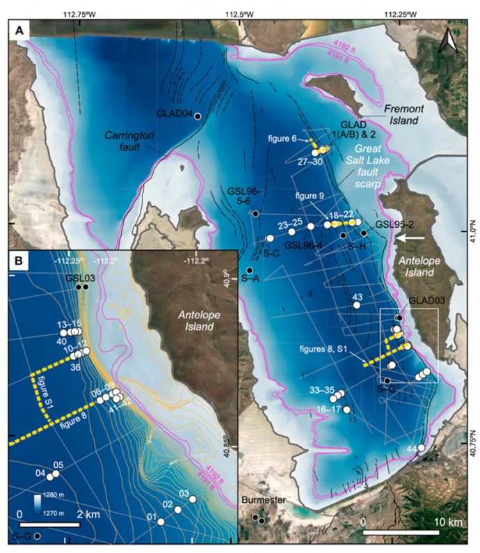
We conducted a compressed high intensity radiated pulse (Chirp) seismic survey of the south arm of the Great Salt Lake near Antelope Island (Figure 2) to develop a basin-wide stratigraphic framework, map faults, identify stratigraphic displacement along the GSLF, and provide stratigraphic context for sediment cores. We extracted 39 cores, each less than 2 m long, guided by the seismic profiles and previous bathymetric data (Baskin and Allen, 2005). The cores form east-west transects across the south arm, overlap spatially with previous (piston) cores, and facilitated the investigation of sediments proximal to the subaqueous GSLF scarp and the 2020 MW 5.7 Magna earthquake, which occurred near the southern Great Salt Lake margin (Figures 1 and 2). Sediment core scans and related laboratory data are available in DuRoss et al. (2026); Chirp seismic data are available in Balster-Gee et al. (2025).
Results
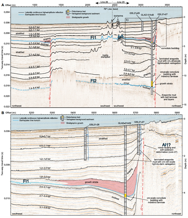
We present seismic stratigraphy, sediment cores, and Bayesian models that address how sediments in the low-relief Great Salt Lake basin respond to earthquake shaking from multiple sources and complement surface-faulting records. Seismic profiles reveal lakebed surface ruptures younger than ~8 ka on the Fremont Island (Figure 3) and Antelope Island sections of the GSLF.
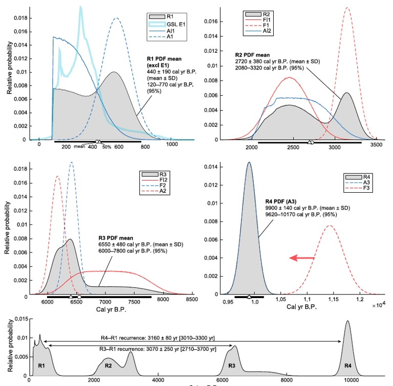
Integrating new and previous data, we interpret MW 6.9–7.3 earthquakes on the GSLF recurring every ~3.2 kyr, including the most recent ~35–45-km-long rupture of the Antelope Island section at ~0.4 ka (R1) and three previous ~60–65-km-long ruptures (R2–R4) spanning both sections (Figure 4).
In GSLF scarp core transects, we interpret massive, normally graded disturbance beds intercalated with laminated bioclastic sediment (Figure 5). These beds likely formed from resuspension and remobilization of surficial sediment, triggered by both GSLF rupture and strong ground motion from nearby WFZ surface-rupturing earthquakes (e.g., DuRoss et al., 2016).
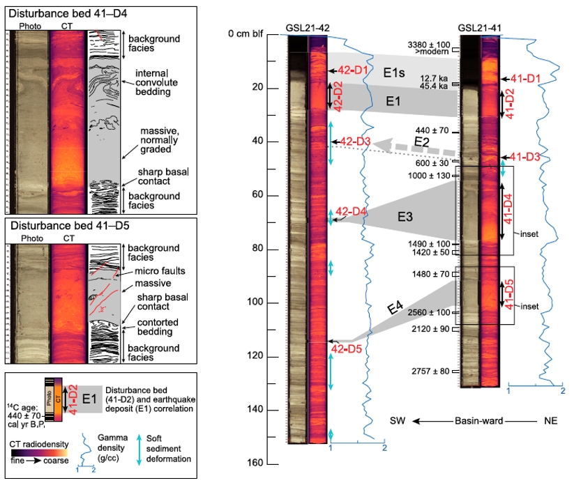
Comparison of Great Salt Lake earthquake deposits E1–E4 with GSLF and WFZ ruptures (Figure 6) supports the interpretation that strong shaking from ruptures both within and proximal to the lake have disturbed sediments in the hanging wall of the GSLF near Antelope Island. Notably, we did not observe evidence of Great Salt Lake sediment disturbance from nearby historical earthquakes (Figure 1).
Great Salt Lake disturbance beds are mostly limited to the GSLF scarp and their lateral correlation yields a composite record of earthquake deposits at about 0.4 ka (E1), ca. 0.7 ka (E2), ca. 1.1 ka (E3), and ca. 1.7 ka (E4). Although E1 likely formed during GSLF rupture R1, E2 and E3 occurred in a GSLF interseismic period and were likely triggered by MMI ~VII shaking in the two most recent earthquakes on the Weber segment of the WFZ (Figure 6). The origin of E4 is less certain, but a WFZ trigger is plausible. Based on these correlations and the absence of sediment disturbance from the 2020 Magna earthquake, we hypothesize a shaking threshold of MMI VI for Great Salt Lake sediment disturbance; however, sensitivity is spatially and temporally dependent, requiring proximity to the rupture source and sloping sediments capable of failure.
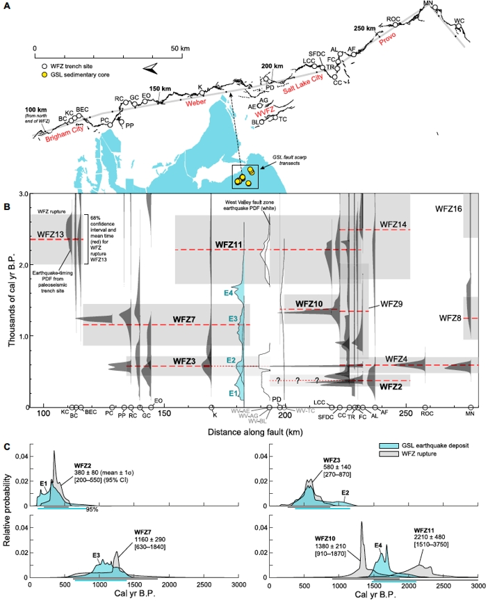
Overall, our study demonstrates that integrating primary (fault-related) and secondary (shaking-related) earthquake evidence can improve our understanding of how sediment responds to shaking in an atypical, low-relief lacustrine basin. These findings extend the use of lake sediments as earthquake archives beyond the steep, high-relief basins where this approach has traditionally been applied and suggest that other low-relief lakes near active faults worldwide may hold similarly valuable, and currently underused, earthquake records.
The Great Salt Lake (Utah, USA) acoustic and sedimentary archive of Wasatch Front earthquakes (2026) by Christopher B. DuRoss, Daniel S. Brothers, Jessica A. Thompson Jobe, Richard W. Briggs, Drake M. Singleton, Sylvia R. Nicovich, Alan R. Nelson, Jared Kluesner, and Jason S. Padgett, is available at https://doi.org/10.1130/B38579.1.
For more information, please contact Christopher DuRoss at cduross@usgs.gov
Acknowledgments
This study was funded by the U.S. Geological Survey Earthquake Hazards Program and the Coastal and Marine Hazards and Resources Program. We thank Amanda Rossi, Jenna Hill, and the Pacific Coastal and Marine Science Center Marine Facility for field support during the 2021 Chirp survey and core collection. Robert Baskin and Charles (Jack) Oviatt provided helpful discussions on Great Salt Lake history and sedimentology. Any use of trade, firm, or product names is for descriptive purposes only and does not imply endorsement by the U.S. Government.
References
- Balch, D.P., Cohen, A.S., Schnurrenberger, D.W., Haskell, B.J., Valero Garces, B.L., Beck, J.W., Cheng, H., and Edwards, R.L., 2005, Ecosystem and paleohydrological response to Quaternary climate change in the Bonneville Basin, Utah: Palaeogeography, Palaeoclimatology, Palaeoecology, v. 221, p. 99–122, https://doi.org/10.1016/j.palaeo.2005.01.013.
- Balster-Gee, A.F., Brothers, D.S., DuRoss, C.B., Kluesner, J.W., Powers, D., Currie, J.E., Del Ferro, P., and Thompson Jobe, J.A., 2025, Chirp sub-bottom data collected in the Great Salt Lake, Utah during USGS field activity 2021-615-FA: U.S. Geological Survey Data Release, https://doi.org/10.5066/P13FCNPJ.
- Baskin, R.L., and Allen, D.V., 2005, Bathymetric map of the south part of Great Salt Lake, Utah, 2005: U.S. Geological Survey Scientific Investigations Map 2894, 1 sheet, scale 1:24,000, https://doi.org/10.3133/sim2894.
- Dinter, D.A., and Pechmann, J.C., 2005, Segmentation and Holocene displacement history of the Great Salt Lake fault, Utah, in Lund, W.R., ed., Proceedings, Basin and Range Province Seismic Hazards Summit II: Utah Geological Survey Miscellaneous Publication 05-2, p. 82–86, https://doi.org/10.34191/MP-05-2.
- Dinter, D.A., and Pechmann, J.C., 2014, Paleoseismology of the Promontory Segment, East Great Salt Lake Fault: U.S. Geological Survey Final Technical Report: U.S. Geological Survey Award Number 02HQGR0105, 23 p.
- DuRoss, C.B., Personius, S.F., Crone, A.J., Olig, S.S., Hylland, M.D., Lund, W.R., and Schwartz, D.P., 2016, Fault segmentation: New concepts from the Wasatch fault zone, Utah, USA: Central Wasatch fault zone segmentation: Journal of Geophysical Research: Solid Earth, v. 121, p. 1131–1157, https://doi.org/10.1002/2015JB012519.
- DuRoss, C.B., Brothers, D.S., Thompson Jobe, J.A., Briggs, R.W., Singleton, D.M., Nicovich, S.R., Nelson, A.R., Kluesner, J., and Padgett, J.S., 2026, The Great Salt Lake (Utah, USA) acoustic and sedimentary archive of Wasatch Front earthquakes: Geological Society of America Bulletin, https://doi.org/10.1130/B38579.1.
- DuRoss, C.B., Brothers, D.S., Thompson Jobe, J.A., Briggs, R.W., Singleton, D.M., Nicovich, S.R., Nelson, A.R., and Padgett, J.S., 2026, Sediment core data from the Great Salt Lake, Utah: U.S. Geological Survey data release, https://doi.org/10.5066/P1PWIZ7S.
- Eardley, A.J., 1938, Sediments of the Great Salt Lake, Utah: Bulletin of the American Association of Petroleum Geologists, v. 22, p. 1305–1411, https://doi.org/10.1306/3D932FFA-16B1-11D7-8645000102C1865D.
- Oviatt, C.G., Madsen, D.B., Miller, D.M., Thompson, R.S., and McGeehin, J.P., 2015, Early Holocene Great Salt Lake, USA: Quaternary Research, v. 84, p. 57–68, https://doi.org/10.1016/j.yqres.2015.05.001.
- Oviatt, C.G., Atwood, G., and Thompson, R.S., 2021, History of Great Salt Lake, Utah, USA: Since the termination of Lake Bonneville, in Rosen, M.R., Finkelstein, D.B., Park Boush, L., and Pla-Pueyo, S., eds., Limnogeology: Progress, Challenges and Opportunities: A Tribute to Elizabeth Gierlowski-Kordesch: Cham, Switzerland, Springer, p. 233–271, https://doi.org/10.1007/978-3-030-66576-0_8.
- Spencer, R.J., et al., 1984, Great Salt Lake and precursors, Utah: The last 30,000 years: Contributions to Mineralogy and Petrology, v. 86, p. 321–334, https://doi.org/10.1007/BF01187137.
- U.S. Geological Survey, 2025, Download Data & Maps from The National Map: https://www.usgs.gov/tools/download-data-maps-national-map (accessed December 2025).
- Wong, I., et al., 2016, Earthquake probabilities for the Wasatch Front region in Utah, Idaho, and Wyoming: Utah Geological Survey Miscellaneous Publication 16-3, 164 p., https://doi.org/10.34191/MP-16-3.




No Comments
No comments yet.