This is a guest blog by Marco Caciagli from INGV.
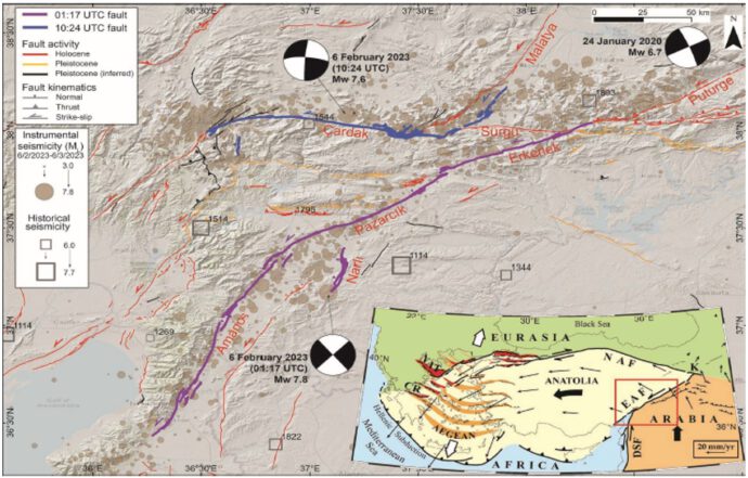
Following the strong (Mw=7.8) Kahramanmaraş earthquake sequence of February 6, 2023 (Fig. 1), within the framework of the collaboration between the Italian Civil Protection Department (DPC) and the Turkish Disaster and Emergency Management Authority (AFAD), a delegation of earthquake geologists, specializing in the collection of coseismic surface effects and representing the DPC’s specific competence centers (INGV, ISPRA, and OGS), conducted a technical mission to Türkiye from May 6 to 13, 2023. This first field survey, carried out in preparation for the subsequent mission planned for October 2023 by the European Task Force “EuQuaGe”, was organized and coordinated by the INGV EMERGEO operational group.
The field survey covered more than 180 km along the central sector of the East Anatolian Fault Zone (Kahramanmaraş‑Pazarcık fault segment; Fig. 1), where coseismic measurements were collected and documented through ground-based photography and drone imagery.
The scientific results of this mission were presented in Pucci et al., (2025). In addition, a detailed visual and kinematic documentation of coseismic surface faulting was published by Caciagli et al. (2026) in the INGV Miscellanea editorial series, titled “A photo and video collection on the surface faulting: the Mw 7.8 Kahramanmaraş (Turkey) earthquake of February 6, 2023”
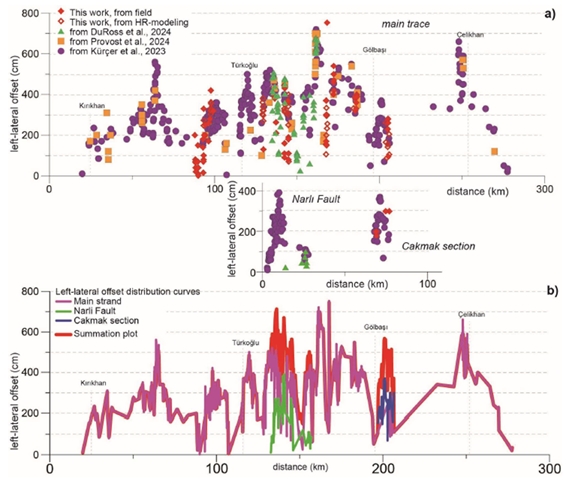
The volume by Caciagli et al. (2026) documents, through 125 photos (selected from more than 4,000) and drone footage, the effects of the surface faulting generated by the Mw 7.8 earthquake of February 6, 2023. In the investigated sector of the fault, displacements exceeding 7 m were measured (Fig. 2), and complex tectonic structures were observed, reflecting strong variability and a combination of strike‑slip, transtensive, and transpressive components.
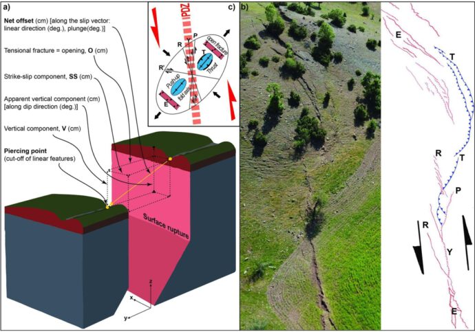
The variety of coseismic structures documented highlights how surface deformation rarely reflects a “pure” kinematic style. Strike‑slip ruptures are accompanied by variable vertical and tensional components. The geometry of structures shown (e.g. Riedel shears, Y‑shears, grabens, pressure ridges) changes rapidly along strike, reflecting both lithological heterogeneity and the complex kinematics of the rupture. These observations provide key constraints for identifying the Principal Displacement Zone (PDZ) and for developing models of distributed slip (Fig. 3).
The publication begins with an overview of the coseismic ruptures, presented through drone video footage (available only in the flip-book version), and is then organized into the main study areas of Nurdağı, Kahramanmaraş, Kisik, Balkar, Gölbaşı, and Hermanli. The paper also includes detailed documentation of widespread liquefaction phenomena in the Gölbaşı area, which produced differential settlements of up to 3–4 m and caused severe damage to buildings. In several cases, adjacent buildings exhibited markedly different structural responses due to local variations in foundation type and depth, as well as in the site stratigraphy of the underlying sedimentary deposits.
Beyond its documentary and educational purpose, the publication is also intended to support readers approaching geological and structural analysis by means of explanatory sketch maps that illustrate the complexities involved in interpreting the surface expression of deep-seated faulting.
Edited by Marco Caciagli, Stefano Pucci, Raffaele Azzaro, Pio Di Manna, Anna Maria Blumetti, Valerio Poggi, Rosa Nappi, Paolo Marco De Martini, Riccardo Civico
References
-
Caciagli, M., Pucci, S., Azzaro, R., Di Manna, P., Blumetti, A. M., Poggi, V., Nappi, R., De Martini, P. M., & Civico, R. (2026). A photo and video collection on the surface faulting: the Mw 7.8 Kahramanmaraş (Turkey) earthquake of February 6, 2023. Miscellanea INGV, 103, 148 pp. https://doi.org/10.13127/misc/103
-
DuRoss, C.B.; Reitman, N.G.; Hatem, A.E.; Mason, H.B.; Lavrentiadis, G.; Asimaki, D.; Milliner, C.; Karakaş, M.; Seçen, B. (2024). Are Field Observations of Surface Rupture Useful? An Example from the 2023 Mw 7.8 Pazarcık, Turkey (Türkiye). Seismol. Res. Lett. 2024, 96, 848–867.
-
Kürçer, A.; Elmacı, H.; Özdemir, E.; Güven, C.; Güler, T.; Avcu, İ.; Olgun, Ş.; Avcı, H.O.; Aydoğan, H.; Yüce, A.A.; et al. (2024). 06 Şubat 2023 Pazarcık (Kahramanmaraş) Depremi (Mw 7.7) Saha Gözlemleri ve Değerlendirmeler. (in Turkish) MTA Genel Müdürlüğü, Rapor No: 14138, 2023, 187 s., Ankara.
- Provost, F.; Karabacak, V.; Malet, J.P.; Van der Woerd, J.; Meghraoui, M.; Masson, F.; Pointal, E. (2024). High-resolution co-seismic fault offsets of the 2023 Türkiye earthquake ruptures using satellite imagery. Sci. Rep., 14, 6834
- Pucci, S.; Caciagli, M., Azzaro, R.; Di Manna, P.; Blumetti, A.M.; Poggi, V.; De Martini, P.M., Civico, R.; Nappi, R.; Unsal, E.; et al. (2025). Examples of Rupture Patterns of the 2023, Mw 7.8 Kahramanmaraş Surface-Faulting Earthquake, Turkiye. Geosciences, 15, 252.


No Comments
No comments yet.