The Motagua Fault in Guatemala is part of the North American – Caribbean plate boundary. It ruptured in a M7.5 earthquake in 1976, killing 23,000 people and causing ca. 230 km of surface ruptures. Very little was known, however, about previous strong earthquakes on this fault. In a new study, we identify five surface-rupturing events in the last 1300 years, including the 1976 quake. We opened a paleoseismological trench and compared our results with archaeological information from nearby sites and historical earthquake data.
Where?
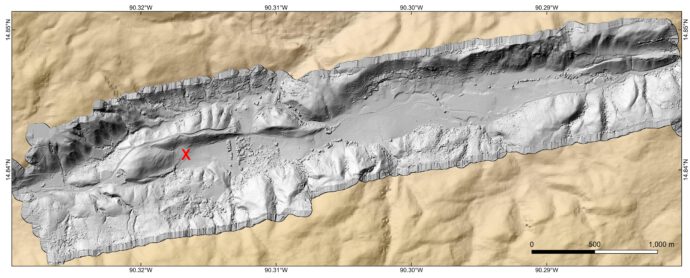
The plate boundary in Guatemala is made up of two main active fault systems, the Motagua and Polochic Faults (Fig. 1). The Motagua Fault ruptured in 1976, any previous ruptures are unknown (Espinosa et al., 1976; Plafker et al., 1976; Schwartz et al., 1979; Clark et al., 2026). The eastern part of the Polochic Fault ruptured in 1785, the western part in 1816 (e.g., White., 1985). We opened a trench close to the western end of the 1976 surface rupture, where the left-lateral strike-slip fault makes a left bend, thus causing local extension and a vertical component of slip (Fig. 2).
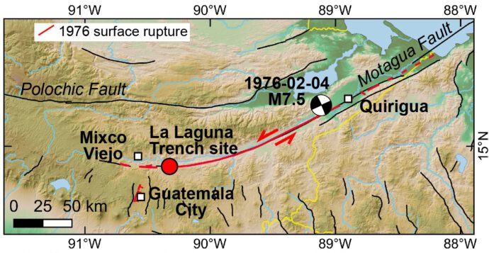
At La Laguna, the slip in 1976 was the highest recorded with more than 3 m of lateral and more than 80 cm of vertical displacement (Espinosa, 1976; Plafker, 1976).
What?
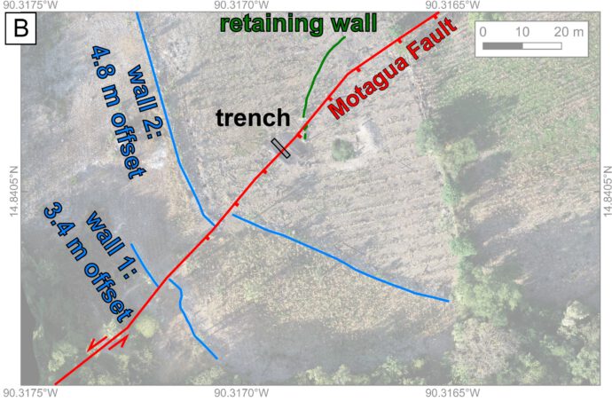
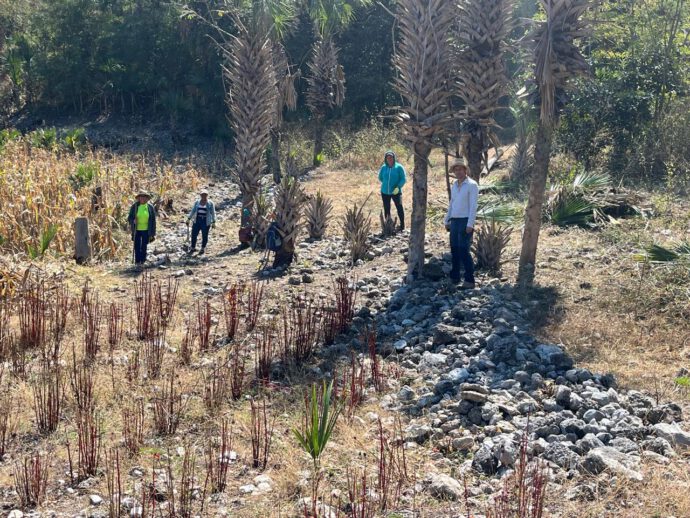
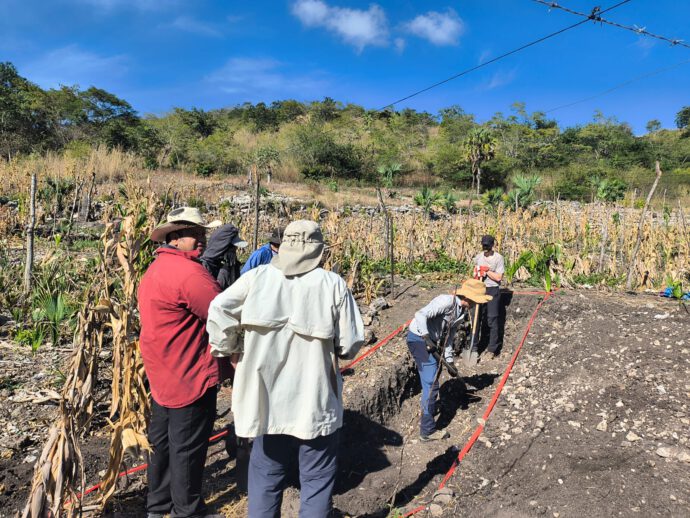
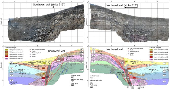
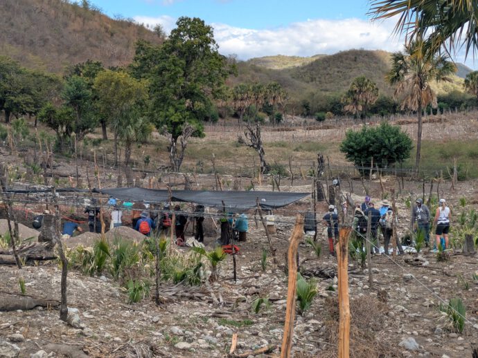
At the trench site, two dry stone walls are laterally offset. One has an offset of 3.4 m and was documented by Plafker in 1976, the other one is offset by 4.8 m (Figs. 3, 4). This means the latter probably recorded two earthquakes. The fault scarp also recorded at least two events, as it is 1.2 m high but the offset in 1976 was only ~80 cm (Plafker, 1976; McEnaney & Clark, 2025). We opened a 7 m-long, 2 m-deep trench by hand (Fig. 5) and identified the main fault zone and a series of colluvial wedges (Fig. 6). Those wedges form on the hanging wall sides of faults when the vertical scarp caused by an earthquake collapses quickly after the event.
Results
We found plenty of charcoals and also pottery sherds that allowed us constraining the dates of the surface-rupturing events (Fig. 6). Five events, including 1976, occurred in the last 1300 years. To further narrow down the earthquake timing, we looked at excavation reports from the archaeological sites of Quirigua and Mixco Viejo, two important Mayan sites along the fault trace. There, collapsed buildings, periods of intense repairs, building reinforcements, and societal changes inform about strong seismic events. We conclude that three earthquakes happened during the 8th–13th centuries and two during the 18th-20th centuries, separated by six centuries without surface ruptures on the Motagua Fault. We also checked the wonderful macroseismic database MARCA-GEHN (Peruzza et al., 2021, 2023) to see which historical quakes are candidates for the penultimate event – several 18th century quakes could have caused the observed ruptures (e.g., White, 1984).
Our data indicate that the average recurrence interval for major earthquakes on the Motagua Fault is ca. 250-330 years. However, the recurrence time is highly variable. Sometimes there are less than 250 years between two consecutive events, sometimes there is a 600 years gap. A similar phenomenon has been observed for the Polochic Fault based on seismites (Brocard et al., 2016). The reason for this variability is not clear yet. The interplay between the Motagua and Polochic Faults might cause this variability or perhaps there are periods of aseismic slip or creep.
The new study is available open access here: https://www.nature.com/articles/s43247-026-03271-y
In a new review paper by Clark et al., we discuss 50 years of research after the 1976 earthquake: https://pubs.geoscienceworld.org/ssa/bssa/article/doi/10.1785/0120250268/725778/A-Fiftieth-Year-Retrospective-on-the-1976-Mw-7-5
Acknowledgements
We thank all local helpers and students who worked with us in the field. We thoroughly enjoyed the discussions during the PATA Days field trip. Tina got a grant for the Guatemala GeoHazards IRES program funded by NSF Grant OISE-2153715. Christoph is financed by DFG project 529303576 “Active tectonics of the Caribbean-North American plate boundary in Guatemala”.
References
- Brocard, G., Anselmetti, F. S., & Teyssier, C. (2016). Guatemala paleoseismicity: from Late Classic Maya collapse to recent fault creep. Scientific Reports, 6(1), 36976.
- Clark, G., McEnaney, T., Maurer, J., Eckert. A., Gao, S. S., Flores, O. G., Yani, R., Niemi, T., Grützner, C., Gomez. F., & Obrist‐Farner, J. (2026). A Fiftieth Year Retrospective on the 1976 Mw 7.5 Motagua Earthquake in Guatemala. BSSA. https://doi.org/10.1785/0120250268.
- Espinosa, A. F. (1976). The Guatemalan earthquake of February 4, 1976: A preliminary report. Geological Survey Professional Paper 1002, 103 pp. US Government Printing Office.
- McEnaney, T., & Clark, G. (2025). 1976 Motagua Earthquake georeferenced database (1.0.0) [Data set], Zenodo. doi: https://doi.org/10.5281/zenodo.17674716.
- Niemi, T. M., Grützner, C., Flores Beltetón, O., Alberto Romero, L., Gomez, F., Maurer, J., McEnaney, T., Daniels, R., Dollens, A., Ebell, H., Pérez Arias, C., Graettinger, A. H., & Obrist-Farner, J. (2026). Five major earthquakes since the Late Classic Maya Period on the Motagua Fault in Guatemala. Communications Earth & Environment. https://doi.org/10.1038/s43247-026-03271-y
- Peruzza, L., et al. (2021). MARCA-GEHN, a prototype macroseismic archive of four Central America countries. Bollettino di Geofisica Teorica ed Applicata, 62, 1-198.
- Peruzza, L., Esposito, E., Rodríguez García, F., & Giunta, G. (2023). A tool for archiving
and updating knowledge about past earthquakes in Central America. In: Earthquake Ground Motion. IntechOpen. https://doi.org/10.5772/intechopen.1003080. - Plafker, G. (1976). Tectonic aspects of the Guatemala earthquake of 4 February 1976.
Science, 193(4259), 1201-1208. - Schwartz, D.P., Cluff, L.S. & Donnelly, T.W. (1979). Quaternary faulting along the Caribbean-North American plate boundary in Central America. Tectonophysics, 52, 432–445.
- White, R. A. (1984). Catalog of historic seismicity in the vicinity of the Chixoy-Polochic and Motagua faults, Guatemala. US Geological Survey USGS-OFR-84-88.
- White, R. A. (1985). The Guatemala earthquake of 1816 on the Chixoy-Polochic fault. BSSA, 75(2), 455-473.


No Comments
No comments yet.