In 2018, back then when we didn’t even knew about Covid-19, I was sitting in a little restaurant in Slovenia with my happy field team. We were exhausted from another long day of geophysical surveys for our active tectonics project and quite thirsty. A colleague of mine, Philipp Balling, had just finished his field work in Croatia and was on his way north to join us for a few days before he would continue to Jena. He arrived late that evening and we had a great time catching up with each others stories from the field. He showed me a few photos, one of them displaying a huge, flat area at the Croatian coast. I was immediately alerted and asked if the Croatian coast was uplifting, because this thing looked like a marine abrasion platform to me. We chatted about uplifted marine terraces until long after midnight, and this is how the story of this paper began.
Understanding the morphology
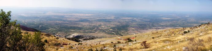
Back home in Jena, we spent an entire day looking at the Adriatic coast with GoogleEarth, checking Philipp’s field photos, and playing around with a DEM. We realized that there were many more of these flat areas, and that in many places they had a staircase morphology.
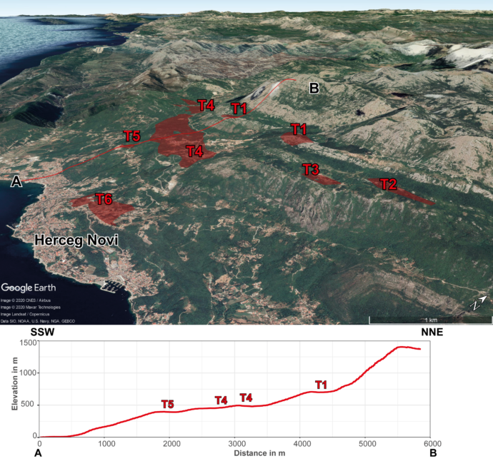
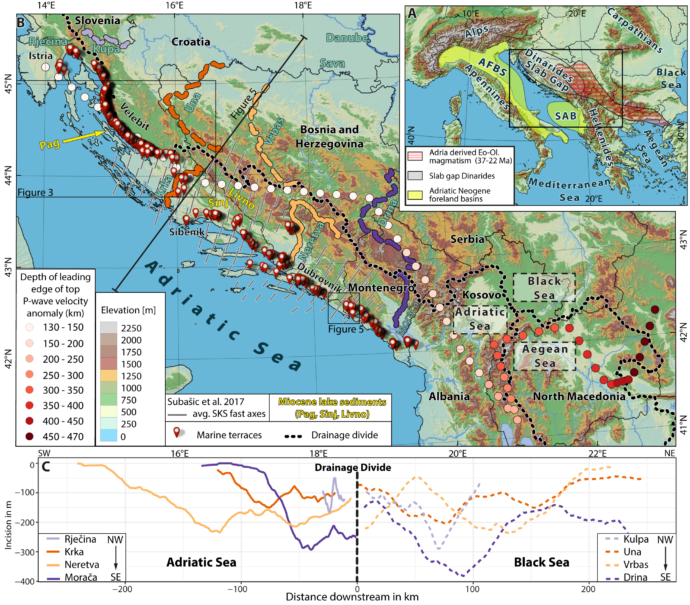
We then realized that we were looking at a huge terrace system that stretches along the coast of the external Dinarides. If we’d know the terraces’ ages, we could work out the uplift history of the Dinaric mountains! Surely this had been described in the literature? Well, apparently not. We were excited. Philipp started to map out all the flat surfaces very carefully and plotted their elevations along the coast. It turned out that they clustered, and that they were present at up to 920 m elevation.
Philipp also realised that the incision of rivers on either side of the Adria-Black Sea watershed was symmetrical – a clear sign that we weren’t looking at the effects of tilt, but of broad uplift. But were these things really marine terraces? Unfortunately, we found neither terrestrial nor marine deposits on top of these flat surfaces. The surfaces affect different bedrock lithologies, and their morphology is neither influenced by bedding dip nor by faults. They cut folds, faults, and tilted strata on various elevations. The only way to explain them is the interaction of broad uplift with sea-level variations. But when did they form and how?
Bracketing the terrace age
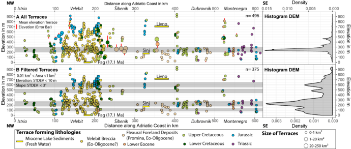
We found that the terraces formed in different lithologies, for example in the Promina Beds, which are mid-Eocene to early Oligocene flexural foreland basin sediments (34-28 Ma). Since the Oligocene, the global sea level never exceeded +100 m compared to today. Therefore, the formation of at least all terraces presently preserved at elevations higher than 100 m above sea level must be due to a regional surface uplift of the Dinarides since the Oligocene.
While all terraces formed in carbonates, we found not a single one within the lacustrine Miocene sediments of the Dinaric Lake System. On Pag Island, Miocene lake sediments crop out at sea level — topographically below all mapped terraces. Since there is no structural offset between the Miocene strata on Pag Island and the nearby marine terraces, the marine terraces must be older than the Miocene sediments on Pag Island (17 Ma). This timing coincides with the emplacement of post-collisional magmatism in the Internal Dinarides.
This was a stunning discovery. These morphological features were preserved for more than 17 million years!
What caused the uplift?
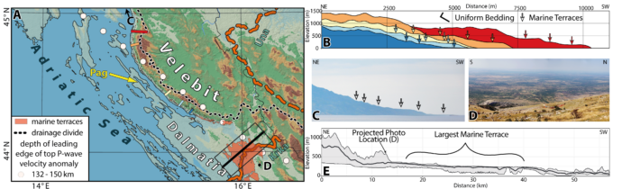
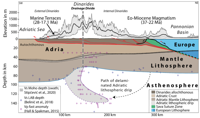
But what caused the broad uplift of the Dinarides back then? The first thing to note is that the terraces coincide with the location of the famous Dinaric slab gap. We looked at published geophysical data: P-wave tomography, S-wave tomography, and SKS splitting data. These data show no evidence of a slab deep enough to disturb the mantle flow pattern in the central Dinarides. However, the top of the leading edge of the high P-wave velocity body underneath the Dinarides correlates with a pronounced change in crustal thickness and, in the northern to central Dinarides, also in lithospheric thickness. All lithosphere-scale changes show a first order correlation with the location of the Adria-Black Sea drainage divide. The non-deformed lithosphere of the Adriatic plate is much thicker than the deformed lithosphere (90 km vs. 60–75 km only). This suggests a post-collisional removal of the orogenic root. P-wave tomography shows an NE-dipping, positive anomaly down to 180 km. Based on its position and shape we interpret this anomaly as delaminated lithospheric mantle of the Adriatic plate.
Conclusions
The extensive, uplifted terrace system is about 28-17 Ma old and still preserved in the landscape. A combination of deep geophysical and surface geomorphic data suggests an Oligo-Miocene delamination event following early Oligocene slab detachment. This lead to Moho- and surface uplift. The delamination is confirmed by a shallow, sub-vertical positive P-wave anomaly. The timing of the uplift also nicely coincides with the emplacement of post-collisional magmatism in the Internal Dinarides.
Our study also shows that it pays off to relax and chat in nice Slovenian restaurants.
How to cite:
- Balling, P., Grützner, C., Tomljenović, B., Spakman, W. & Ustaszewski, K., 2021. Post-collisional mantle delamination in the Dinarides implied from staircases of Oligo-Miocene uplifted marine terraces. Sci Rep 11, 2685.


No Comments
No comments yet.