The Geoblogosphere is full of links on the Gorkha Earthquake in Nepal – and we have some links on this major event, too. But we found also some few more links on creating beautiful scientific posters, hilarious geomemes, and more. Today is Friday and here are your links!
The devastating Gorkha Earthquake (Nepal Earthquake) widely covered the news and social media feeds during the last two weeks. While the number of fatalities (over 7800, ICIMOD) is still rising, the focus slowly turns into recovery and repair.
The Center for Disaster Management and Risk Reduction Technology (CEDIM), put together a report on the impact of the earthquake, social and economic effects. Their release is one among several good scientific and readworthy reports (see for example the USGS special poster, or the EMSC-CSEM earthquake details).

The CEDIM earthquake impact report. Please click on the image to see the full PDF report.
Scientists from all over the world immediately went into action to help using satellite imagery and remote sensing data.
Using FINDER, NASA and DHS scientists were able to locate and save four people who were trapped by debris. FINDER is a radar-based device that can detect hartbeats through meters of debris and concrete.

By loading the tweet, you agree to Twitter’s privacy policy.
Learn more
DigitalGlobe opened access to their satellite data to support disaster response efforts – and many people took part in helping. First results were produced quickly, and the Tomnod team and volunteers are still mapping blocked roads and damaged buildings.

Tomnod map on damage mapping with DigitalGlobe data, here shown on an OSM map.
Many, many more contributed — by mapping landslides, for example. The Earthquakes without Frontiers project (also on Twitter) quickly responded with landslide hazard maps and released preliminary guidelines for relief and response activities connected to landslide hazards shortly thereafter.
By loading the tweet, you agree to Twitter’s privacy policy.
Learn more
Their latest update includes a landslide map, which is also available as PDF.
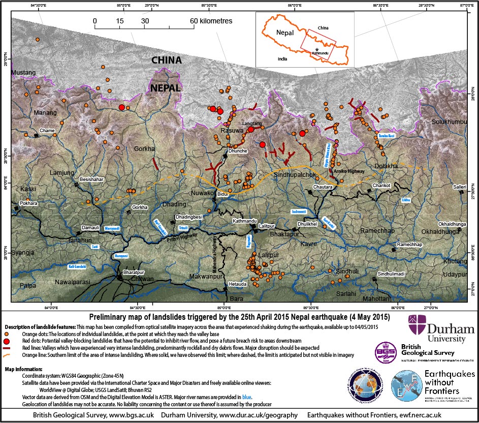
The EwF, BGS, and Durham University preliminary landslide map.
Speaking of landslides, Dave Petley reported figures and photographs on the Langtang region and the Arniko highway on the Landslideblog.
By loading the tweet, you agree to Twitter’s privacy policy.
Learn more
Don’t miss this EOS article: What Can We Learn About Disaster Preparedness from Nepal’s Quake? – an interview with Brian Tucker.
“The need for geoscientists to provide information about seismic risk and risk reduction options is critically important but, most curiously, is underrated by disaster risk professionals and, I suspect, also by geoscientists.” – Brian Tucker
…and then this interview with him in The New York Times: Trying to Stay Ahead of Earthquake Disasters.
It’s tough to stop linking hundreds of other readworthy blogs and articles on the Gorkha Earthquake – but I have got some other links for you:
Natalie Rodriguez presented the dos and dont’s of preparing posters for conferences with a nice infographic! I personally dislike posters that are too static (or boring?) but creating fancy, modern and interactive posters is so full of pitfalls, that you cannot repeat this advice:

Tips for designing better research posters
And now, for the lovers of internet memes, see this hilarious buzzfeed post: If The Internet Was Around During Each Geologic Period – I can haz cone shell? There are many more memes to discover!

Nobu Tamura / Alex Kasprak / BuzzFeed / Via en.wikipedia.org
How can I name an unnamed natural feature? is a guideline by the USGS Geographic Names Information System – and makes me wonder whether there are such guidelines for geological features in other countries as well. I recently named a previously unknown normal fault after a nearby lake in a paper (still pending) without asking any Chinese decision maker.
And then there is this beautiful video on the rock cycle:
Kayaç Döngüsü & Rock Cycle#jeoteknik #jeomuh1000kadro #jeomorfoloji #jeoloji #geology #Geologist #kayaçdöngüsü #rockcycleJeoloji Mühendisi Tolga Gözütok
Posted by Jeoloji Mühendisleri on Dienstag, 5. Mai 2015
And here are some of my latest favourite tweets:
By loading the tweet, you agree to Twitter’s privacy policy.
Learn more
By loading the tweet, you agree to Twitter’s privacy policy.
Learn more
By loading the tweet, you agree to Twitter’s privacy policy.
Learn more
By loading the tweet, you agree to Twitter’s privacy policy.
Learn more
By loading the tweet, you agree to Twitter’s privacy policy.
Learn more
By loading the tweet, you agree to Twitter’s privacy policy.
Learn more
By loading the tweet, you agree to Twitter’s privacy policy.
Learn more
Have a nice weekend!


No Comments
No comments yet.