Moderate to strong earthquakes commonly produce secondary effects (landslides, liquefaction, tsunamis), which worsen the impact of the seismic event, both during the emergency and recovery phases.
Landslides can be triggered by events of M above 5 or so, and stronger events can produce thousands of landslides. Landslide inventories were compiled for dozens of events and the relations between Mw and maximum distance or area affected by landslides have been analyzed (e.g., Keefer, 1984; Rodriguez et al., 1999). On the other hand, the total area affected by landslides is one of the metrics used to assign the ESI intensity (Environmental Seismic Intensity; Michetti et al., 2007).
Seismic sequences may be rather complex, and several events may occur in the same region in a short time interval. The total area affected by landslides thus is the result of the spatial and temporal evolution of the seismic sequence.
During July-August 2018, Lombok (Indonesia) was hit by a sequence of events, reaching a maximum magnitude of Mw 6.9 (on August 5th and August 19th). I analyzed the spatial distribution of the landslides triggered by the sequence and compared it with eyewitnesses’ reports (“Did You Feel It” questionnaires) – see my last paper if you’re interested in the results (here a full-text view-only version).
Since I think that this topic is under-studied, I wanted to analyze more case histories; to this end, I write a code to make things easier – I’m new to coding, so be indulgent if it’s not stylish!
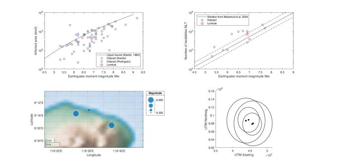
Provided the input data (position and M of the earthquakes, number of triggered landslides and affected area), the code returns a figure like the following one. Data are related to the Lombok case study. The plots show:
- Area affected by landslides (km2) as a function of earthquake magnitude Mw. Data from Keefer (1984) and Rodriguez et al. (1999). Solid line is approximate upper bound enclosing all data from Keefer’s work.
- Relation between earthquake moment magnitude Mw and number of triggered landslides NLT. The solid line is the correlation and the dashed lines are the corresponding error bounds from Malamud et al., 2004.
- Location map, symbol dimension scales with magnitude.
- Schematic sketch of the regions where landslides are expected, given the epicenter location and the upper bound curve from Keefer (1984). I’m definitely unhappy with the rendering, but you know, I was getting crazy with geographical coordinates in Matlab… in the paper, I did it with a graphic software 😊
The code can be downloaded here from Github
Feel free to modify and improve it. When using, please cite the paper containing the embryonic idea (Ferrario, 2019). Please be aware that Keefer’s datapoints were retraced and the upper bound was graphically captured and equation derived with Grabit. Thus, information plotted in part 4) brings some degree of inaccuracy.
References cited:
Ferrario M. F. (2019) Landslides triggered by multiple earthquakes: insights from the 2018 Lombok (Indonesia) events. Natural Hazards 98(2), 575-592, https://doi.org/10.1007/s11069-019-03718-w
Keefer DK (1984) Landslides caused by earthquakes. Geol Soc Am Bull 95(4):406–421
Malamud BD, Turcotte DL, Guzzetti F, Reichenbach P (2004b) Landslides, earthquakes, and erosion. Earth Planet Sci Lett 229(1–2):45–59
Michetti AM, Esposito E, Guerrieri L, Porfido S, Serva L, Tatevossian R, Vittori E, Audemard F, Azuma T, Clague J, et al. (2007) Environmental Seismic Intensity Scale 2007—ESI 2007, Memorie Descrittive della Carta Geologica d’Italia, Vol. 74, Servizio Geologico d’Italia– Dipartimento Difesa del Suolo, APAT, Rome, Italy, 7–54, available at http://www.isprambiente.gov.it/en/publications/technical‑periodicals/descriptive‑memories‑of‑the‑geological‑map‑of/intensity‑scale‑esi‑2007?set_language=en
Rodriguez C, Bommer JJ, Chandler RJ (1999) Earthquake-induced landslides: 1980–1997. Soil Dynamics and Earthquake Engineering 18 (1999) 325–346

My Homepage | 2020-07-01|19:46 (UTC)
… [Trackback]
[…] There you will find 53301 more Infos: paleoseismicity.org/landslides-triggered-by-multiple-earthquakes-a-matlab-code/ […]