During the month of March 2014, Sascha and I along with Tobi and Lauretta (BSc students from RWTH University) were in Greece for fieldwork. The fieldwork campaign started on the island of Crete; our institute at RWTH Aachen has a joint project with Mainz University to carry out paleotsunami investigations on the island. The western part of Crete was uplifted by approximately 9 m during the 21st July AD 365 earthquake and also hit by the associated tsunami. Due to the strong seismic and highly tsunamigenic activity of the nearby Hellenic Trench, it is suggested that numerous earlier tsunamis have also struck the island. Our project aims to determine the variability of tsunami deposits (tsunamites) in space and time. We met and our colleagues from Mainz University and got started working in Paleochora and Sougia (Figs. 1 and 2), two ancient fishing villages on the southwest coast. The ancient harbours of these villages are now dry land due to the 9 m uplift in AD 365. Therefore, in order to determine the subsurface structure of these uplifted harbours, and find good drilling areas, we started off with GPR and ERT. Both our team and the Mainz team drove from Germany allowing us to bring a lot of our equipment with us; together we had GPR, ERT, t-LiDAR, d-GPS and a tracked drilling rig. After a few boreholes were drilled, we found a possible tsunamigenic sandy gravel layer at the Sougia site; samples were taken for dating. Along the coast of southwestern Crete there is evidence of the AD 365 uplift in the cliffs. At Sougia a series of uplifted calcareous algal rims are located in the cliffs either side of the bay (Fig. 3). Research suggests that the large amount of uplift in the area may not have occurred only from one large event (i.e. the AD 365 event) but from smaller events with interseismic subsidence culminating in the AD 365 event (Scheffers & Scheffers, 2007). This allows for many rims to form at varying heights. We scanned this area with high resolution t-LiDAR and plan to analyse the backscatter intensity of each rim to help determine the relative exposure time.
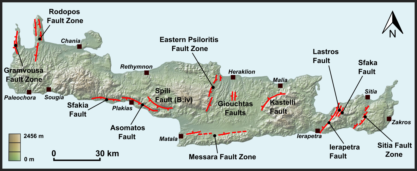
Fig. 1. Map of Crete showing the major active faults on the island.
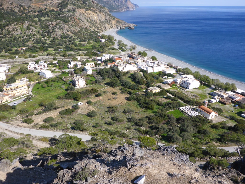
Fig. 2. The uplifted ancient harbor of Sougia

Fig. 3. Uplifted algal rims at Sougia.
After around a week’s fieldwork in southwest Crete we left the Mainz team and headed to the Lastros – Sfaka graben in eastern Crete (Fig. 1). The Lastros fault, which is part of the Ierapetra Fault Zone, is a spectacular fault forming the SE boundary to Kapsos Ridge (Fig. 4). The fault has a prominent bedrock scarp that is juxtaposed against Quaternary colluvial/alluvial sediments. On the Lastros fault, and on many other faults on Crete, cemented colluvium is attached to the fault plane. The cemented colluvium comes in large ‘lobe like’ structures (Fig. 4) and also in thinner sheets. We are studying the spatial extent of this cemented colluvium using GPR and t-LiDAR, and aim to determine what processes are behind its formation and preservation. The Sfaka fault is located in the opposing valley to the Lastros fault. We carried out trenching (road-cut) investigations in this area last September and needed to supplement the data with some further sampling and pseudo-3D GPR profiling (Fig. 5) to determine whether the logged structures in the trench can be visualised at depth within the trench walls. Our friend and colleague Aggelos Pallikarakis from the Agricultural University of Athens joined us on Crete. He is originally from the island we stayed with his family in Chania for one night. His mother is an amazing cook and made us a typical Cretan feast for dinner involving his father’s homemade wine and Raki. Just thinking of the roast lamb now is making me hungry!

Fig. 4. The Lastros fault showing the ‘lobe’ of cemented colluvium.

Fig 5. 3D GPR profiling at the Sfaka fault (Sept 2013)
Once work on Crete was finished we made our way to the Corinth area on mainland Greece for the final part of our stay. Here we helped some colleagues from Cologne University with cosmogenic nuclide dating of the Pissia fault, one of the faults that ruptured during the 1981 earthquake series. We also helped some archaeological colleagues from the University of Virginia with some t-LiDAR scanning of the Late Bronze Age (1600-1200 BC) settlement of Thebes (Fig. 6). For our own research we spent around a week at the Kaparelli Fault which also ruptured during the 1981 earthquake series. Here we carried out extensive preudo-3D GPR and also ERT at the site of Trench 1 excavated by Kokkalas et al. (2007). This trench is still open and we used it to fine tune our geophysical instruments to see if the structures within the trench can be spatially traced at depth within the trench wall, and also in two areas either side of the trench (Fig. 7). This involved cleaning and re-logging the trench, scanning it with high-resolution t-LiDAR (Fig. 8) and carrying out GPR on the trench walls; we also carried out a lot of gardening (removing small trees, shrubs and plants) on the ground surface either side of the trench to unsure the GPR antennas had good coupling with the ground surface. Preliminary results are good and we hope to publish the results this year.

Fig 6. t-LiDAR scanning of the Late Bronze settlement of Thebes.
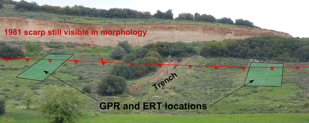
Fig 7. View of Kaparelli trench site and locations of GPR and ERT profiling.

Fig. 8. Sascha carrying out high resolution t-LiDAR scanning of the Kaparelli trench wall.
Further reading:
Kokkalas and Koukouvelas 2005. Fault-scarp degradation modeling in central Greece: The Kaparelli and Eliki faults (Gulf of Corinth) as a case study. Journal of Geodynamics 40 (2005) 200–215.
Kokkalas et al. 2007. Paleoseismicity of the Kaparelli fault (eastern Corinth Gulf): evidence for earthquake recurrence and fault behaviour. Boll.Soc.Geol.It. (Ital.J.Geosci.), Vol. 126, No. 2.
Scheffers, A., Scheffers, S., 2007. Tsunami deposits on the coastline of west Crete (Greece). Earth and Planetary Science Letters 259, 613‑624.
Shaw, B., Ambrayses, N.N., England, P.C., Floyd, M.A., Gorman, G.J., Highham, T.F.G., Jackson, J.A., Nocquet, J.‑M., Pain, C.C., Piggott, M.D., 2008. Eastern Mediterranean tectonics and tsunami hazard inferred from the AD 365 earthquake. Nature Geoscience 1, 268‑276.
Stiros S.C. 2001. The AD 365 Crete Earthquake and possible seismic clustering during the fourth to sixth centuries AD in the Eastern Mediterranean: a review of historical and archaeological data. Journal of Structural Geology 23, 545-562.
Stiros, S., 2010: The 8.5+ magnitude, AD 365 earthquake in Crete: Coastal uplift, topography changes, archaeological and historical signature. Quaternary International 216, 54-63.
Tsoudolos et al. 2008. Tectonic geomorphology of the easternmost extension of the Gulf of Corinth (Beotia, Central Greece). Tectonophysics Vol. 453 pp 211–232.

Nick Austin | 2018-10-26|15:18 (UTC)
Did you publish your report. I am interested to know if the Malia basin was effected by the events you investigated on Crete. There is evidence there that sea level changes may have happened.
regards
Nick
Christoph Grützner | 2018-10-26|20:53 (UTC)
Nick, check this open access paper: https://www.solid-earth.net/7/323/2016/ and also this one: https://www.cambridge.org/core/journals/quaternary-research/article/hangingwall-colluvial-cementation-along-active-normal-faults/2564600FFA8C70AF9EE67DD6E8197C21
Plus, there’s this book chapter: https://books.google.de/books?hl=de&lr=&id=_JInDwAAQBAJ&oi=fnd&pg=PA191&dq=jack+mason+crete&ots=zTBlrR6cXv&sig=z4kevsR1exMl8b3cqnPgWEbKXBM#v=onepage&q=jack%20mason%20crete&f=false
Cheers
Christoph